Why latitude and longitude worksheets belong in geography instruction
Latitude and longitude worksheets give teachers a direct way to teach location, direction, and map-reading precision without turning the lesson into a long lecture. In an upper-elementary or middle-school geography block, students need repeated practice seeing how a map grid works, not just hearing the definitions once. A well-designed set of latitude and longitude worksheets helps them connect vocabulary such as Equator, prime meridian, hemispheres, and coordinates to actual places on a map or globe.
That matters because coordinate skills sit at the center of broader social studies work. When students can read a pair of coordinates, they can locate regions, compare continents, discuss climate zones, and interpret why places are described as north, south, east, or west. Worksheets also make formative assessment easier. A teacher can quickly see whether students are mixing up latitude with longitude, reversing coordinate order, or struggling to identify which hemisphere a place belongs to.
For planners building a geography sequence, latitude and longitude worksheets are especially useful during an introduction unit, a review cycle, or a short intervention group. They offer enough structure for independent practice, but they still leave room for discussion with wall maps, atlases, and globes.
What students actually practice with latitude and longitude worksheets
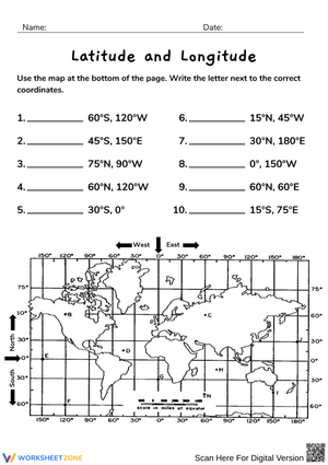
The best latitude and longitude worksheets move beyond labeling lines on a globe. They ask students to interpret a coordinate grid, identify locations from given coordinates, and explain how the Equator and the prime meridian organize the world into hemispheres. That combination of recognition and application is what helps the concept stick.
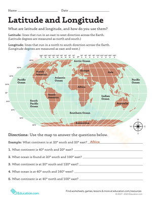
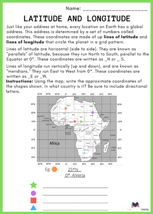
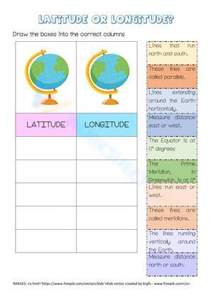
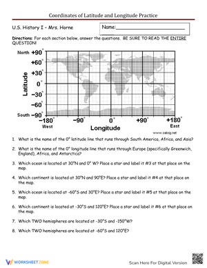
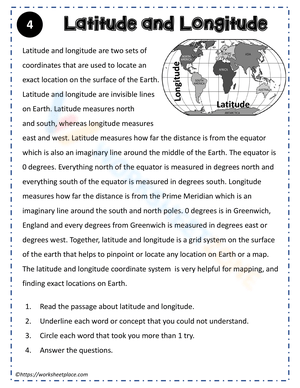
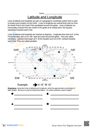
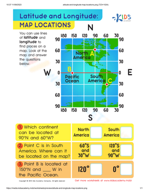
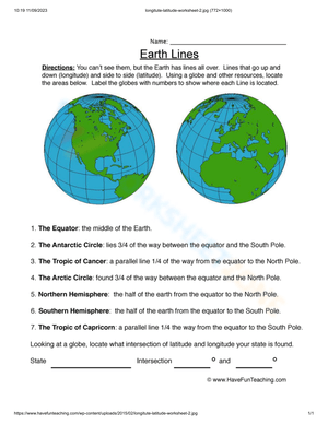
In most classrooms, students first learn that latitude measures how far a place is north or south of the Equator, which is 0 degrees latitude. Then they learn that longitude measures how far a place is east or west of the prime meridian at Greenwich, which is 0 degrees longitude. After that, the real work begins: reading both values together as a coordinate pair and finding a matching location.
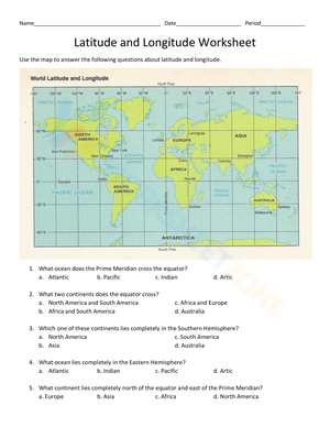
Britannica explains that latitude is measured from 0° at the Equator to 90° north or south, while National Geographic Education identifies longitude as distance east or west from the 0° prime meridian. Those two 0° reference lines create the global grid students use to pinpoint exact locations.
Strong worksheet practice usually includes tasks like these:
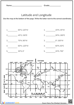
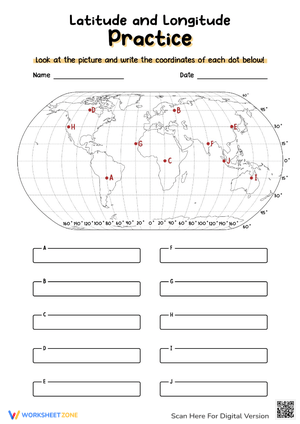
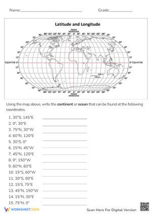
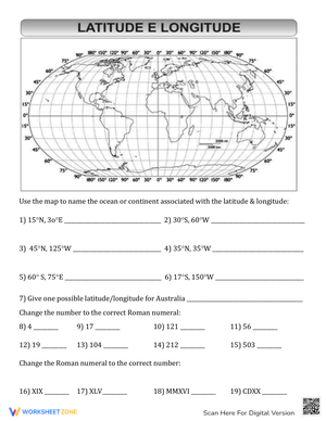
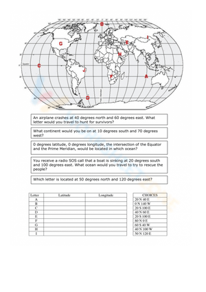
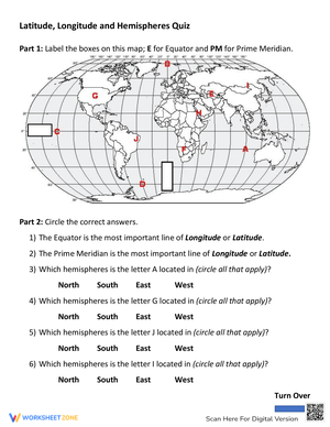
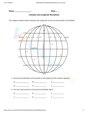
- circling lines of latitude and lines of longitude on a map
- naming whether a place is in the Northern, Southern, Eastern, or Western Hemisphere
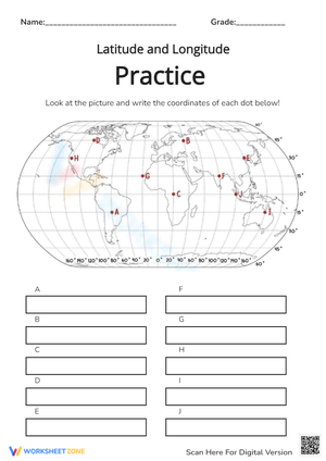
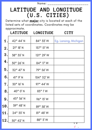
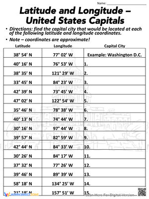
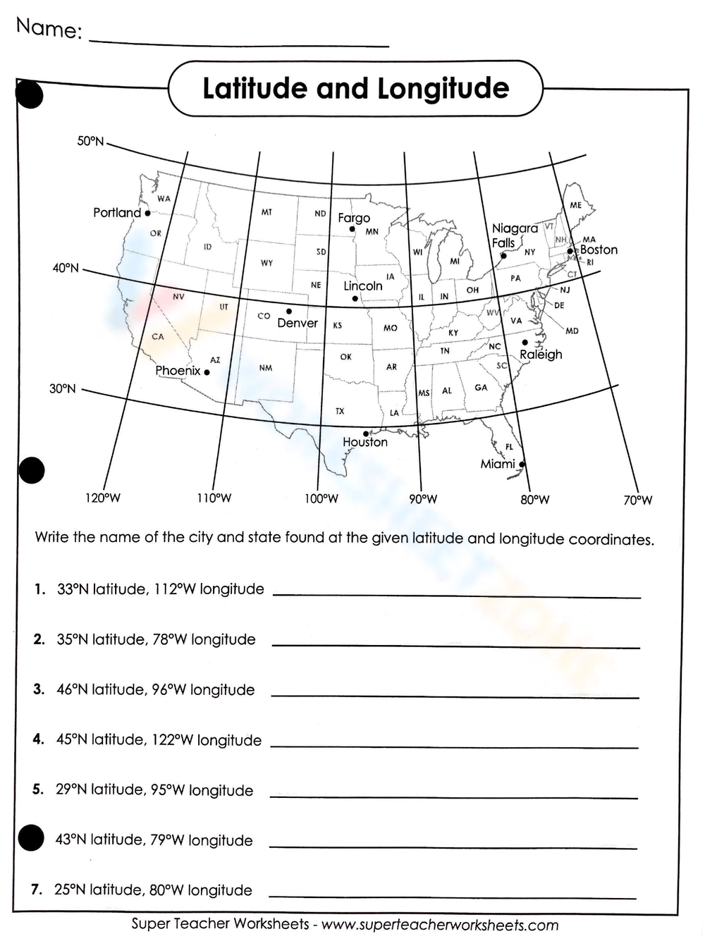
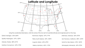
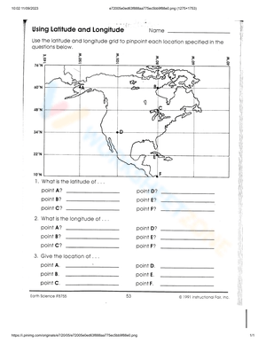
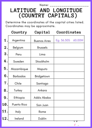
- matching coordinate pairs to cities, landmarks, or fictional locations
- writing coordinates in the correct order
- reading coordinates shown in degrees, and sometimes noticing that coordinates can also appear in minutes, seconds, or decimal degrees
When those task types appear together, the worksheet stops being a simple vocabulary page and becomes a map-skills routine teachers can build on throughout the year.
Why this topic fits upper-elementary and middle-school geography
Latitude and longitude worksheets fit especially well in grades 4-7 because students at this level are ready to combine abstract vocabulary with visual-spatial reasoning. They can usually understand that the Equator and prime meridian are reference lines, but they still benefit from repeated guided examples before the skill becomes automatic.
In upper elementary, teachers often use these worksheets to introduce map grids and world geography language. The focus tends to be on identifying the Equator, distinguishing horizontal and vertical lines, and finding simple coordinates on a clean map. In middle school, the same worksheet topic can become more analytical as students compare locations across hemispheres and explain relative position.
That vertical progression is one reason latitude and longitude worksheets are so flexible. The core content stays stable, but the cognitive demand can shift. A teacher can use the same concept for whole-class instruction, reteaching, enrichment, or a quick check for understanding before moving into regions, climate, migration, or physical geography.
How to choose latitude and longitude worksheets that build real understanding
Not every worksheet supports good instruction. Some pages ask students to memorize terms in isolation, while others guide them through the logic of the coordinate system. Teachers usually get better results from worksheets that combine direct labeling, short retrieval tasks, and map-based application.
Look for materials that make the coordinate structure visible. Students should be able to clearly see horizontal latitude lines and vertical longitude lines. The page should also reinforce that coordinates are read as a pair, not as two unrelated numbers. If the worksheet asks students to locate a place, the map needs enough clarity for them to track the lines accurately.
A common instructional mistake is assigning coordinate practice before students have internalized the two 0° anchor lines. When that happens, errors multiply because students are guessing direction instead of reasoning from the Equator and prime meridian. A stronger sequence is to anchor every early worksheet in those two fixed references, then expand to hemispheres and exact coordinates once orientation is consistent.
It also helps when a worksheet includes a mix of easier and harder items. Teachers can use the early items as confidence builders and the later questions as evidence of transfer. If students can label lines correctly but cannot identify whether a coordinate belongs in the Eastern or Western Hemisphere, the worksheet has done its job by revealing the exact gap.
Classroom Implementation
Latitude and longitude worksheets work best when they are part of a short instructional cycle rather than a stand-alone printable handed out at the end of class. One practical routine is to begin with a teacher model on a projected map, then move into partner talk, and finally assign independent worksheet questions. That sequence lets students rehearse the language before they work alone.
Another effective option is station-based practice. One station can focus on labeling the Equator, prime meridian, and hemispheres. A second can ask students to read coordinate pairs from a map. A third can use a globe or classroom atlas so students compare the worksheet grid with a real-world representation. That blend supports students who need concrete reference points before they feel secure with abstract map symbols.
Teachers can also use latitude and longitude worksheets as a five-to-ten-minute spiral review. A short warm-up once or twice a week keeps the skill active without taking over the geography block. Because the task format is predictable, students can focus on accuracy rather than on learning new directions each time.
For intervention, keep the map less crowded and reduce the number of coordinate pairs on the page. For enrichment, ask students to create their own mystery coordinates for classmates to solve. Both versions preserve the same core skill while adjusting the workload and the level of independence.
Common student errors and the feedback that corrects them
Most errors with latitude and longitude worksheets are highly predictable, which makes feedback more efficient. One frequent issue is confusing latitude with longitude. Students may remember the terms but still reverse which lines run across the map and which run from pole to pole. Another common error is reading the coordinate pair in the wrong order.
Teachers can respond best with feedback that points back to structure. Instead of simply marking an answer wrong, direct students to identify the Equator first, then decide whether the location is north or south. Next, have them identify the prime meridian and decide whether the location is east or west. That process helps them reason through the grid step by step.
Students also benefit from hearing precise language repeatedly. Saying, latitude tells north or south; longitude tells east or west, gives them a usable verbal frame during independent work. When a worksheet shows the same error pattern across many students, that usually signals a teaching opportunity rather than a motivation issue. Re-modeling one or two examples with the whole class is often more productive than assigning another full page immediately.
Frequently Asked Questions: using latitude and longitude worksheets well
1. What do latitude and longitude worksheets teach?
They teach students how to use the Earth's coordinate grid to locate places precisely. Most pages cover the Equator, the prime meridian, hemispheres, and how latitude and longitude work together as coordinate pairs on maps and globes.
2. What grade levels use latitude and longitude worksheets?
They are most often used in upper-elementary and middle-school geography lessons. Teachers can simplify the task for younger learners with clear maps and basic labeling, or increase the challenge for older students with more complex coordinate reading.
3. How do students read coordinates on a map?
Students first identify latitude, which shows how far north or south a place is from the Equator at 0 degrees. Then they identify longitude, which shows how far east or west a place is from the prime meridian at 0 degrees. Together, those values locate the place on the map grid.
4. What is the difference between latitude and longitude?
Latitude measures north-south position relative to the Equator, while longitude measures east-west position relative to the prime meridian. Teachers often emphasize the difference by having students compare line direction, hemisphere language, and coordinate order during worksheet practice.