


Views
Downloads
Latitude and Longitude Road Trip | Grade 5 Essential
Paste this activity's link or code into your existing LMS (Google Classroom, Canvas, Teams, Schoology, Moodle, etc.).
Students can open and work on the activity right away, with no student login required.
You'll still be able to track student progress and results from your teacher account.
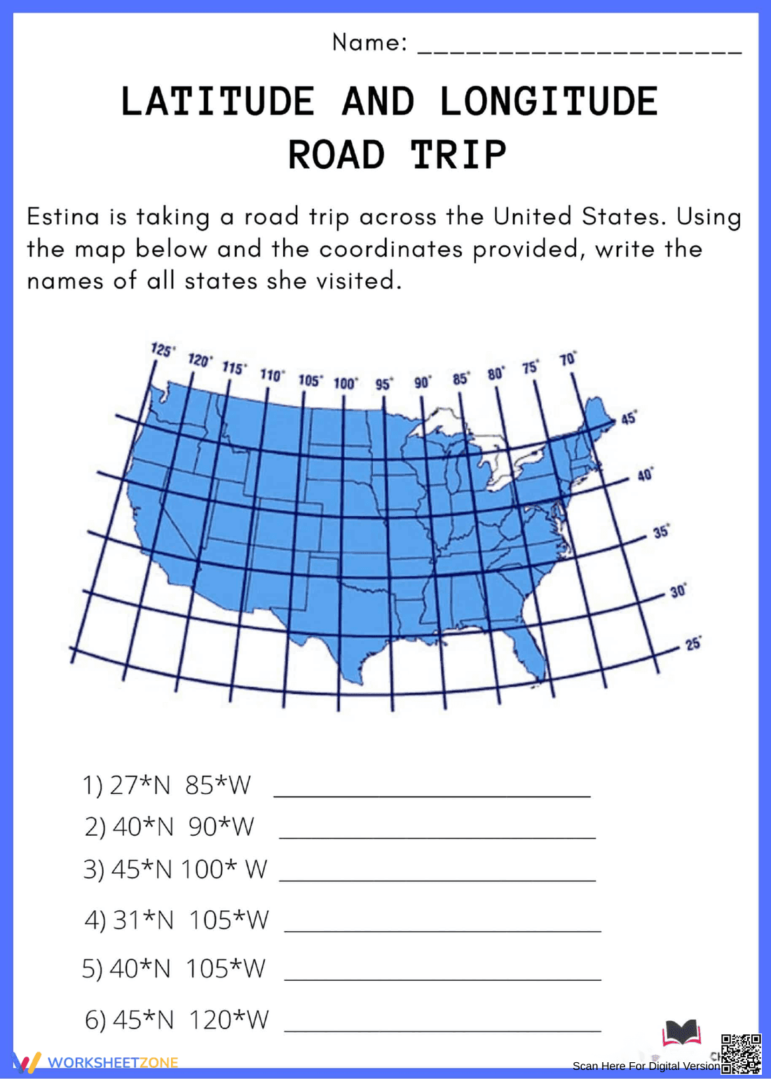
This Grade 5 geography worksheet helps students master the coordinate system by tracking a fictional road trip across the United States. By applying latitude and longitude data to a physical map, learners develop spatial awareness and technical reading skills. It provides a practical, engaging way to practice locating specific geographic points with precision and speed.
At a Glance
- Grade: 5 · Subject: Social Studies
- Standard:
CCSS.ELA-LITERACY.RI.5.7— Use information from maps to solve problems and locate answers efficiently- Skill Focus: Latitude and Longitude Coordinates
- Format: 1 page · 6 problems · Answer key included · PDF
- Best For: Independent practice or geography centers
- Time: 15–20 minutes
Inside this resource, you will find a clear, labeled map of the United States overlaid with a coordinate grid. The worksheet features 6 specific coordinate pairs that correspond to different states. Students must cross-reference the numbers on the axes to identify the correct location, writing the state name on the provided lines. The layout is clean and focused to minimize distractions.
This resource is designed for a zero-prep classroom workflow. First, print the single-page PDF in under 30 seconds. Next, distribute the sheets to students for a quick warm-up or exit ticket. Finally, review the six answers as a whole group to check for understanding. Total teacher preparation time is under 2 minutes, making it an ideal choice for busy mornings.
This activity aligns with CCSS.ELA-LITERACY.RI.5.7, which requires students to draw on information from multiple print or digital sources to solve problems efficiently. By interpreting the visual data of the map grid, students meet the rigorous demands of informational text analysis. This standard code can be copied directly into lesson plans, IEP goals, or district curriculum mapping tools.
Use this worksheet during the independent practice phase of a geography lesson after introducing the concepts of parallels and meridians. It also serves as an excellent formative assessment tool; observe if students confuse the X and Y axes to identify who needs immediate intervention. Expected completion typically takes 15 to 20 minutes depending on prior map exposure.
This is ideal for general education fifth graders, but the visual nature makes it accessible for English Language Learners practicing academic vocabulary. It pairs naturally with a classroom wall map or a digital atlas for extended exploration. It is also a reliable option for emergency sub plans due to its self-explanatory instructions and clear student objectives.
According to the RAND AIRS 2024 report on geography education, the integration of spatial reasoning tasks into elementary curricula significantly improves a student's ability to interpret complex informational graphics. This worksheet focuses on the core skill of using latitude and longitude coordinates to identify locations on a map, directly supporting the requirements of CCSS.ELA-LITERACY.RI.5.7. By engaging with 6 distinct coordinate problems, students move beyond theoretical knowledge into practical application. Research from Fisher & Frey (2014) emphasizes that scaffolded visual tasks, such as this road trip activity, help bridge the gap between abstract concepts and real-world utility. This resource provides the necessary structured practice to ensure students can locate answers efficiently and solve geographic problems with high accuracy. It is a high-utility tool for any social studies unit focused on map skills, providing measurable evidence of student mastery in coordinate systems.