


Views
Downloads
Latitude and Longitude Practice | Essential Grade 6 Map
Paste this activity's link or code into your existing LMS (Google Classroom, Canvas, Teams, Schoology, Moodle, etc.).
Students can open and work on the activity right away, with no student login required.
You'll still be able to track student progress and results from your teacher account.
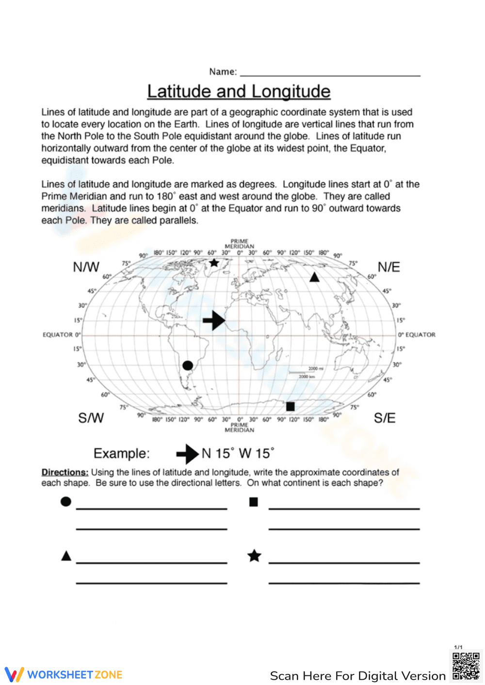
This Grade 6 geography worksheet helps students master the global coordinate system by locating specific points on a world map. By identifying the latitude and longitude of various shapes, learners develop the spatial awareness necessary to navigate physical maps. Students distinguish between parallels and meridians while applying directional notation.
At a Glance
- Grade: 6–7 · Subject: Social Studies
- Standard:
CCSS.ELA-LITERACY.RI.6.7— Integrate map information to locate specific geographic coordinates- Skill Focus: Latitude and Longitude
- Format: 1 page · 8 problems · Answer key included · PDF
- Best For: Geography bell ringers or map skills intro
- Time: 15–20 minutes
What's Inside
This single-page resource features a world map labeled with the Equator, Prime Meridian, and degree increments. Students are presented with four distinct shapes—a circle, square, triangle, and star—placed at specific global coordinates. The worksheet includes a worked example to model the correct format for writing coordinates using directional letters. Below the map, students must provide the approximate coordinates and the corresponding continent for each shape, totaling eight distinct tasks.
Zero-Prep Workflow
The zero-prep workflow is designed for efficiency. First, print the single-page PDF (30 seconds). Second, distribute to students as a warm-up or exit ticket (1 minute). Third, review the four coordinate pairs and continent names using the provided answer key (5 minutes). Total teacher prep time is under 2 minutes, making this an ideal resource for substitute folders or last-minute geography skill reinforcement.
Standards Alignment
The primary standard addressed is CCSS.ELA-LITERACY.RI.6.7: "Integrate information presented in different media or formats as well as in words to develop a coherent understanding of a topic." This worksheet requires students to translate visual data from a map into quantitative coordinate pairs. Both standard codes can be copied directly into lesson plans, IEP goals, or district curriculum mapping tools.
How to Use It
Use this worksheet during the "We Do" phase of a geography lesson. After introducing the concepts of the Equator and Prime Meridian, project the map and complete the first shape together. Then, allow students to work independently to find the remaining three shapes. It also functions as an effective formative assessment; observe if students confuse the order of latitude and longitude. Completion typically takes 15 to 20 minutes.
Who It's For
This resource is designed for Grade 6 and Grade 7 students beginning their study of world geography. It is particularly helpful for visual learners who benefit from seeing shapes plotted directly on a grid. Continent identification makes it a natural pairing for introductory units or map skills anchor charts.
According to the RAND AIRS 2024 report on social studies instruction, the ability to synthesize spatial data from maps is a foundational literacy skill that bridges the gap between abstract coordinate systems and physical world geography. This worksheet targets CCSS.ELA-LITERACY.RI.6.7 by requiring students to integrate visual information from a global projection with text-based coordinate prompts. By identifying specific shapes like the star and triangle across different hemispheres, learners practice the precise application of latitude and longitude degrees. Research from Fisher & Frey (2014) emphasizes that scaffolded visual tools, such as the included world map with labeled Equator and Prime Meridian lines, significantly reduce cognitive load during the initial phases of geographic mastery. This resource provides a structured environment for students to transition from guided examples to independent identification of both coordinates and continents. It serves as a reliable instrument for formative assessment in middle school geography units.