Reading a topographic map is one of the few earth science tasks that asks students to picture three dimensions from a flat sheet of paper. That gap between what the eye sees and what the lines actually represent is the reason topographic map worksheets earn a permanent spot in a grades 4-8 science block. Strong practice pages give teachers a low-prep way to move students from simply spotting contour lines to calculating gradient and sketching a profile, one checkable step at a time.
The catch is that not every worksheet pulls its weight. The best ones isolate a single skill per task so you can see exactly where a student's reasoning breaks down, then reteach that one move instead of the whole topic.
What Topographic Map Worksheets Actually Teach
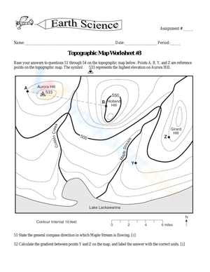
A packet is only as useful as the skills it isolates. Strong topographic map worksheets don't just ask students to color a map or copy vocabulary; they break the topic into discrete, checkable moves. Students trace a contour line and read its value, identify the contour interval, and use that interval to find the elevation of an unlabeled point. From there they calculate gradient between two points, read and apply map scale, spot hachured lines that mark a depression, determine which direction a river flows, and eventually construct a topographic profile along a line they choose. When you evaluate a set of worksheets, look for that progression built into the pages rather than one busy diagram with a dozen unrelated questions stacked around it. Isolated skills are easier to grade, easier to reteach, and easier to hand to a substitute on short notice.
Sequencing the Skills from Grade 4 to Grade 8
Topographic map instruction stretches across several grades, so a single search term ends up covering very different lessons. In grade 4, map work usually stays at the pattern-reading level: students analyze and interpret data from maps to describe where mountains, valleys, and rivers sit. That elementary framing lines up with NGSS 4-ESS2-2, which asks students to analyze and interpret data from maps to describe patterns of Earth's features. By grades 6 through 8, the same topic deepens into contour intervals, gradient math, and profile construction. A match-the-landform page that fits a fourth-grade class would bore a seventh grader, and a gradient worksheet would sink most fourth graders. Sort your worksheets by skill before you sort them by grade, and the teaching sequence almost writes itself.
The Skill That Trips Students Up Most
Across years of earth science classrooms, the single point where topographic map worksheets stall is the contour interval, not the elevation number itself. Students read a labeled 500-foot line without trouble, but when four unlabeled lines sit between two labeled ones, they guess instead of dividing. Teaching the interval as a division problem first - the difference between two labeled lines divided by the number of spaces between them - corrects more wrong answers than any amount of extra map coloring.
Scale is the other quiet stumbling block, and it helps to anchor it in a real number. According to the U.S. Geological Survey, its classic 7.5-minute topographic quadrangles are printed at a scale of 1:24,000, meaning one inch on the map equals 2,000 feet on the ground. That single ratio lets students convert map distance to real distance before they ever calculate elevation or gradient.
Classroom Implementation
Slot topographic map worksheets into a unit at three predictable moments. Use a short contour-line identification page as a warm-up on the day you introduce the vocabulary, so students meet the terms before the diagram gets crowded. Mid-unit, run a station rotation: one station reads elevation, one calculates gradient, one builds a profile, and one checks river-flow direction. Students who struggle with spatial reasoning get repeated small doses instead of a single overwhelming packet. Before the unit test, hand out a mixed worksheet as a formative checkpoint, grade it quickly, tally which of the five or six core skills students miss most, and spend the review day on that skill alone. That turns a worksheet from busywork into a diagnostic that tells you exactly where reteaching will pay off. For a mixed-ability class, keep three versions of the same map ready:
- Basic: label the given contour lines and name the highest and lowest points.
- On-level: find the elevation of unlabeled points using the contour interval.
- Stretch: calculate gradient between two points and sketch the profile.
Same map, three entry points, one grading key.
Building Up to a Topographic Profile
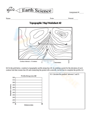
The profile is where all the smaller skills come together, and it deserves its own dedicated worksheet rather than a single question tacked onto an elevation page. To sketch a profile, students draw a line across the map, mark where each contour line crosses it, transfer those crossings down to a grid, plot the matching elevation for each, and connect the dots into a side view of the terrain. Break that into two sessions: one where students only mark and transfer the crossings, and a second where they plot and connect. Splitting the task keeps the mechanics from blurring together and gives you a clean checkpoint after the first step. When students finish, ask them to describe the shape in words - gentle slope, steep cliff, flat valley floor - so the profile connects back to a real landform instead of staying an abstract zigzag.
Frequently Asked Questions
1. What grade level is right for introducing topographic maps?
Basic contour-line reading fits grade 4, where map work centers on describing patterns of Earth's features rather than doing math. Contour intervals, gradient, and profile construction are better placed in grades 6 through 8. The reliable move is to match the worksheet to the specific skill you're teaching, not just to the grade number printed on the folder.
2. Which standards do topographic map worksheets support?
At the elementary level they align to NGSS 4-ESS2-2, which asks students to analyze and interpret data from maps to describe patterns of Earth's features. In middle and high school earth science, the same map-reading skills extend into analyzing surface processes and landforms, so a single worksheet type supports a long arc of learning across grade bands.
3. What should a worksheet practice besides reading elevation?
Look for contour interval, gradient calculation, map scale, hachured depression lines, river-flow direction, and topographic profile construction. Reading elevation is only the entry point; the analysis skills that actually show up on unit assessments live in those other tasks, so a worksheet that stops at elevation leaves most of the standard untouched.
4. How do these worksheets fit an earth science unit on landforms or erosion?
Topographic maps make surface change visible. Once students can read elevation and gradient, they can predict where water runs fastest, where slopes are steepest, and where erosion is most likely, connecting the lines on the map to the processes actively shaping the landform your unit is studying.
5. Can topographic map worksheets be used for review instead of new teaching?
Yes. The same page works as a modeled lesson during instruction and as independent review before a test, so the timing and your role change while the map stays the same. Reserve the modeled version for introducing a skill and the independent version for checking whether it stuck.












 Interactive Worksheet Maker
 Quiz Maker
 Word Search Maker
 Crossword Puzzle Maker
 Word Scramble Generator
 Sentence Scramble Generator
 Handwriting Worksheet Generator
 Name Tracing Generator
 Fill In The Blank Generator