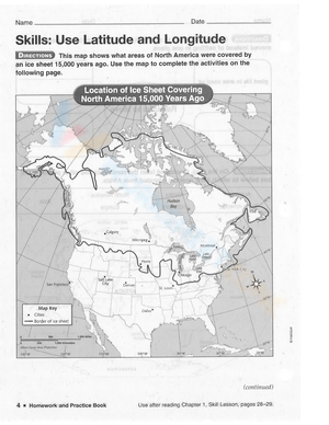
Latitude and longitude can feel abstract until students see the lines on a map and use them to find real places. That is why latitude and longitude pdf worksheets for 4th grade work so well in elementary social studies. They turn map vocabulary into visible, repeatable practice that fits the way 4th graders learn. Instead of only hearing that latitude measures north or south from the Equator and longitude measures east or west from the Prime Meridian, students can trace, label, and apply those ideas on a printed page.
In a US classroom, this kind of worksheet is especially useful during geography units that introduce continents, oceans, hemispheres, and world maps. Teachers often need practice materials that can support direct instruction, independent work, and reteaching without building a new activity from scratch each time. A printable PDF format makes that easy. You can project the same skill on the board, hand out copies for guided practice, and use another page later for review.
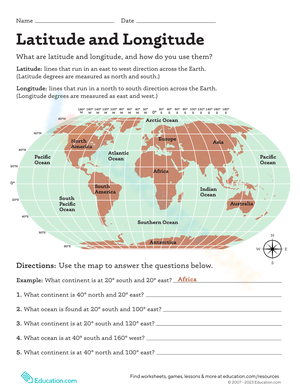
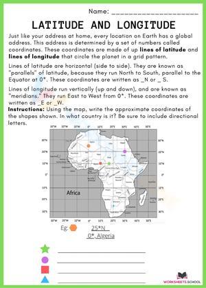
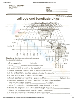
For Grade 4, the goal is not advanced navigation. The goal is solid map-grid basics. Students need to recognize what the Equator and Prime Meridian do, notice how lines help organize the globe, and begin locating simple coordinates with confidence. Good worksheets keep that focus clear.
The Core Skills Students Practice
Strong 4th grade practice should build a sequence, not just ask students to memorize terms. First, students need to tell latitude and longitude apart. Next, they need to connect those lines to hemispheres and map position. Then they can move into reading simple coordinates and locating places on a world map. When a worksheet follows that progression, it supports both first-time instruction and later review.
A useful set of latitude and longitude pages often helps students practice these skills:
- Identifying the Equator and Prime Meridian on a map
- Explaining that latitude shows north or south position
- Explaining that longitude shows east or west position
- Using hemispheres as part of map descriptions
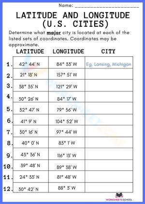
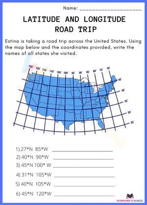
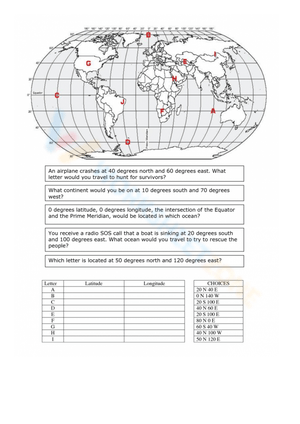
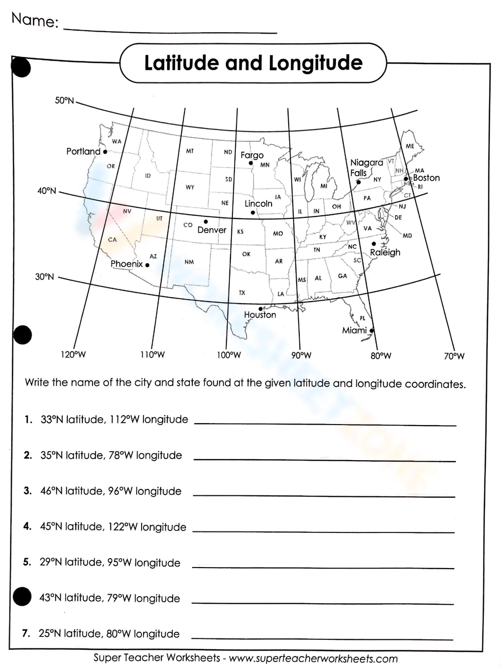
- Finding places from simple coordinates
- Matching continents or oceans to approximate map locations
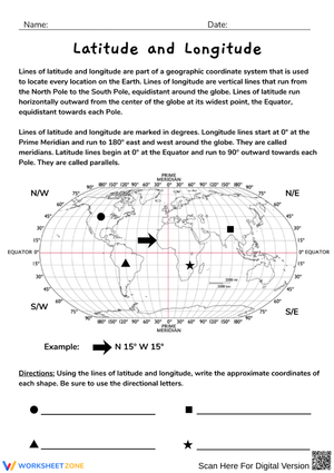
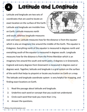
Britannica Kids: latitude and longitude explains a clear two-part idea that fits elementary instruction: latitude measures north or south from the Equator, while longitude measures east or west from the Prime Meridian. That simple 2-line distinction gives 4th graders the background they need before they start reading coordinates on practice maps.
That sequence matters because students often look successful when they can repeat definitions, but they may still struggle when asked to apply them. A worksheet that moves from vocabulary to map use gives teachers a better picture of whether students actually understand the grid.
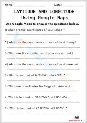
Why Printable PDF Format Works in Real Classrooms
Printable PDFs are practical because they are easy to assign, easy to save, and easy to reuse. If you are planning a geography lesson with limited prep time, a ready-to-print worksheet can cover warm-up, partner work, independent practice, or an exit check without extra formatting.
That flexibility is one reason teachers look for latitude and longitude pdf worksheets for 4th grade instead of open-ended activity ideas alone. A PDF lets you keep the map layout consistent from class to class. Students see the same type of grid, the same labeling style, and the same response format. That consistency matters when you are teaching a skill that depends on careful reading.
Printable worksheets also help in everyday school situations:
- Centers where students need quiet, self-directed map practice
- Homework that reinforces classroom vocabulary
- Substitute plans that need clear directions and low setup
- Early finisher folders for social studies enrichment
- Small-group reteaching after a quick check shows confusion
When the format is simple, teachers can spend their energy on instruction instead of rebuilding maps or rewriting coordinate questions.
Classroom Implementation
One effective way to teach this topic is to move from concrete to visual to independent. Start with a globe or wall map and point out the Equator and Prime Meridian. Then model how latitude lines run east and west but measure north and south position, while longitude lines run north and south but measure east and west position. After that, hand students a worksheet that asks them to label, identify, and locate simple points.
In many Grade 4 classrooms, a short lesson flow works well:
- Mini-lesson: define latitude, longitude, Equator, and Prime Meridian
- Guided practice: solve 2 or 3 coordinates together on a projected map
- Independent work: complete a printable page with map questions
- Partner check: compare answers and explain the thinking
- Exit task: identify one location from a final coordinate pair
This approach keeps the worksheet in its best role. It is not replacing instruction. It is extending instruction with focused repetition. That is especially helpful for students who need to see the same geography structure several times before it clicks.
Teachers can also rotate the same skill through the week. Use one page as a bell ringer on Monday, a second page for centers on Wednesday, and a short coordinate check on Friday. Students get repetition without feeling like they are doing the exact same task each day.
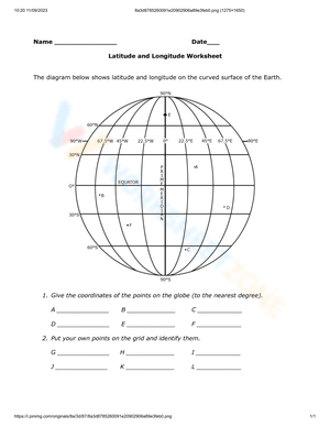
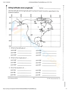
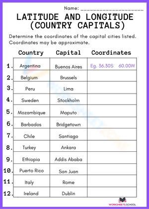
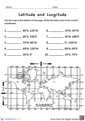
What to Look for in Strong Coordinate Practice
A common Grade 4 error is not confusion about the words themselves, but confusion about the order of reading coordinates. Students may know both terms yet still reverse them when they move from vocabulary practice to actual map tasks. Worksheets are most effective when they repeatedly cue students to read latitude first and longitude second, so the routine becomes automatic before more complex geography work appears later.
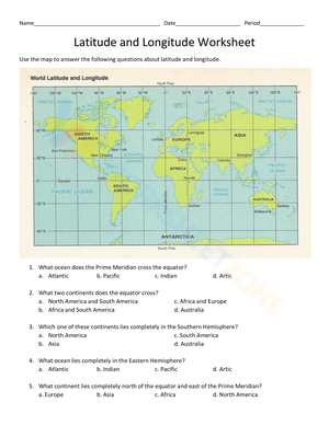
Look for tasks that ask students to label major lines, sort locations by hemisphere, and find places from basic coordinates. Those are strong signs that the worksheet is aligned with elementary map-skills instruction rather than upper-grade geography expectations.
Using Worksheets for Review and Quick Assessment
These worksheets are also useful when you need a fast read on student understanding. Teachers can use the same format for formative assessment during a geography unit. A short worksheet with 5 to 8 items can show whether students are ready to move on to broader mapping tasks, or whether they still need support with the basic lines and directions that organize a world map.
These are practical review uses in a school setting:
- Pre-assessment before starting a map-skills unit
- Mid-unit check after teaching hemispheres and coordinates
- Friday review sheet before a quiz
- Small-group intervention for students who need reteaching
- End-of-unit evidence to include with classroom performance data
For teachers, that balance is important. A worksheet should not just fill time. It should help you see what students can do independently, what needs another model, and which learners are ready for a slightly harder map challenge.
Frequently Asked Questions
1. What should 4th graders know about latitude and longitude?
At minimum, 4th graders should know that latitude tells how far north or south a place is from the Equator, while longitude tells how far east or west a place is from the Prime Meridian. They should also be able to use those ideas to read simple map coordinates and identify hemispheres on a basic world map.
2. How do you teach latitude and longitude in a simple way?
Start by teaching the major lines on a globe or map, then model a few coordinates together before assigning independent practice. Keep directions short, use clear maps, and repeat the same routine across several examples. That helps students move from vocabulary to actual map use.
3. Are these worksheets good for homework or centers?
Yes. A printable PDF is a good fit for homework, centers, early finisher work, and substitute plans because students can complete it with limited setup. It also gives teachers a consistent format for checking whether students can identify lines, hemispheres, and simple coordinates on their own.
4. Do the PDFs include world map coordinate practice?
That is one of the most useful features to look for. In Grade 4, world map coordinate practice helps students connect abstract terms to real map positions. The strongest worksheets include uncluttered maps, basic coordinate questions, and prompts tied to continents, oceans, or clearly marked locations.