


Views
Downloads


Grade 3 Latitude & Longitude — Printable No-Prep Worksheet
Paste this activity's link or code into your existing LMS (Google Classroom, Canvas, Teams, Schoology, Moodle, etc.).
Students can open and work on the activity right away, with no student login required.
You'll still be able to track student progress and results from your teacher account.
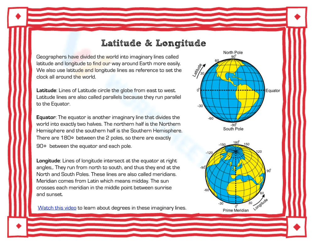
This Grade 3 geography worksheet teaches students how to read and use latitude and longitude coordinates to locate specific places on a world map. By combining an informational reading passage with hands-on mapping activities, learners build essential spatial reasoning and map-reading skills.
At a Glance
- Grade: 3 · Subject: Social Studies
- Standard:
CCSS.ELA-LITERACY.RI.3.7— Use information from illustrations and words to understand a text- Skill Focus: Latitude and Longitude
- Format: 5 pages · 9 problems · Answer key included · PDF
- Best For: Independent practice or sub plans
- Time: 25–35 minutes
What's Inside
This comprehensive mini-unit includes an introductory reading page explaining the equator, prime meridian, and coordinate lines. Students then apply this knowledge using a provided world map grid to complete 9 specific tasks, such as coloring hemispheres, identifying continents by coordinates, and labeling cardinal directions. A complete visual answer key is included for easy grading. The structured format ensures that children do not feel overwhelmed, as they can easily flip back to the reading passage to find the definitions of parallels and meridians.
Zero-Prep Workflow
- Print (1 min): Simply print the informational text, map, and question sheet for each student.
- Distribute (1 min): Hand out the packets along with colored pencils or crayons needed for the mapping tasks.
- Review (1 min): Use the visual answer key to quickly check student maps or project it for self-correction.
Total teacher prep time is under 2 minutes, making this an ideal resource for emergency sub plans or immediate classroom use.
Standards Alignment
Aligned to CCSS.ELA-LITERACY.RI.3.7, requiring students to use information gained from illustrations (e.g., maps, photographs) and the words in a text to demonstrate understanding of the text. This resource also supports foundational geography standards for locating major continents and oceans. Both standard codes can be copied directly into lesson plans, IEP goals, or district curriculum mapping tools.
How to Use It
- Independent Geography Station: Assign the reading and map activity after a brief whole-class introduction to globes.
- Formative Assessment: Observe students as they color the equator and locate coordinates; check if they confuse latitude (horizontal) with longitude (vertical) to guide immediate reteaching.
Expected completion time is 25–35 minutes.
Who It's For
Designed for 3rd-grade students, this resource is also appropriate for 2nd-grade enrichment or 4th-grade review. The clear visual diagrams and step-by-step coloring tasks provide built-in scaffolding for visual learners. Special education teachers will appreciate the concrete, color-coded nature of the mapping tasks, which helps students with processing challenges break down complex spatial information into manageable steps. Pair this with a physical globe or an interactive digital map lesson for maximum impact.
Integrating visual data with informational text is a critical component of elementary education. According to RAND AIRS 2024, students who engage in multimodal learning tasks, such as combining reading passages with map-reading exercises, demonstrate a higher retention rate in spatial reasoning skills. By practicing with this latitude and longitude worksheet, learners actively use information from illustrations and words to understand a text, directly supporting CCSS.ELA-LITERACY.RI.3.7. This structured approach ensures that foundational geography concepts are anchored in both literacy and practical application.