6th Grade Topographic Map Worksheets PDF for Science and Geography Practice
These 6th grade topographic map worksheets pdf resources give Earth science and geography teachers a printable set focused on the inferential reading that contour maps actually require — not just locating a point, but interpreting what the pattern of lines reveals about slope, elevation change, and landform shape. Students who can read a political map fluently often hit a wall the first time they look at contour lines, and the set addresses that transition directly.
The Specific Skills Targeted
Contour maps ask students to do something they are not accustomed to: read absence as data. The distance between lines tells them as much as the lines themselves. Each worksheet in the set builds toward that understanding through a clear progression.
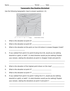
- Contour line fundamentals: Students identify that each line connects points of equal elevation and use the contour interval to calculate heights between labeled index contours.
- Slope comparison: Students mark areas of close versus wide line spacing and explain in writing which terrain is steeper and why.
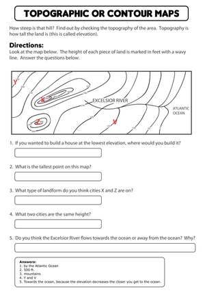
- Landform recognition: Students label hills, valleys, ridges, and depressions from contour patterns, distinguishing a closed-loop hill from a closed-loop depression by the presence of hachure marks.
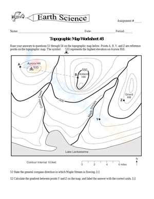
- Water flow prediction: Students use elevation patterns to trace where runoff would likely move, connecting map reading to surface processes in Earth science.
- Index and intermediate contours: Students use thicker labeled lines as anchors, then count intermediate lines to estimate elevations at unmarked points.
The sequencing matters. Students who try to identify landforms before they understand line spacing tend to guess from shape rather than reason from data. Moving through the skills in order — from what a contour line represents to what a pattern of lines reveals — keeps students from locking in that guessing habit early.
Mistakes Students Make That These Worksheets Help You Catch
The single most common error in student work is misreading closed contour loops. Students regularly label every closed oval as a hill. They miss that a depression closes inward as well — and without checking for hachure marks, they cannot distinguish one from the other. A student who correctly labels a 200-meter hilltop will turn around and call a volcanic crater depression a "small mountain" on the very next question.
Slope comparison trips up a different group. Students understand intellectually that closer lines mean steeper slope, but they apply that rule inconsistently when two slopes appear on the same map. Many students compare the number of contour lines rather than the spacing between them, which leads to wrong conclusions when one slope covers more horizontal distance. These 6th grade topographic map worksheets pdf resources include questions that ask students to mark and compare line spacing directly — which catches that misreading before it becomes a fixed habit.
A third error involves water flow direction. Students frequently predict that water flows along valleys, which is sometimes true, but they struggle to use contour V-shapes to confirm direction. When contour lines form a V pointing upstream, water flows in the opposite direction. Students who learn this in class often forget to apply it on the worksheet, especially when the V is subtle or the map orientation is unfamiliar.
How to Build These Worksheets Into Your Lesson Plans
The most effective use pattern in grade 6 Earth science is to introduce one new concept per session, then use a single worksheet for structured independent practice before moving forward. A Monday lesson on contour line basics, followed by the corresponding worksheet for the last 15 minutes of class, gives students enough time to consolidate the idea before Tuesday's lesson on slope comparison adds new complexity.
A technique worth building into your introduction: before students answer any questions, have them trace every line at a given elevation interval in colored pencil — say, every 100-meter index contour in orange. This cuts line-skipping mistakes by a wide margin and helps students see elevation bands as a layered landscape rather than a tangle of overlapping loops. It adds about three minutes to the task and noticeably reduces elevation-reading errors when you review the work afterward.
For station rotations, one station can cover vocabulary and labeling, a second can focus on slope comparison, and a third can present a more detailed map with challenge questions. For substitute days, the worksheets function well with minimal setup — a brief set of directions on the board alongside the printed pages is enough for students to work independently through most of the task.
Adjusting the Worksheets for a Range of Learners
For students who struggle with spatial reasoning, start with maps that show fewer than five contour lines and clearly marked index contours at round numbers. Have them answer only elevation and high-versus-low questions before adding slope comparison. Sentence frames move written responses forward when students know the answer but cannot produce the academic language: This slope is steeper because the contour lines are ___ or Water would flow toward the ___ because that area has a lower elevation of ___. Both frames require students to fill in map-specific evidence rather than copy a generic statement.
On-level students handle mixed worksheets that cycle through vocabulary, elevation reading, slope comparison, and brief written explanation within the same task. That combination mirrors the way questions appear on unit assessments, which makes these 6th grade topographic map worksheets pdf resources equally useful for lesson practice and pre-assessment review without requiring separate materials for each purpose.
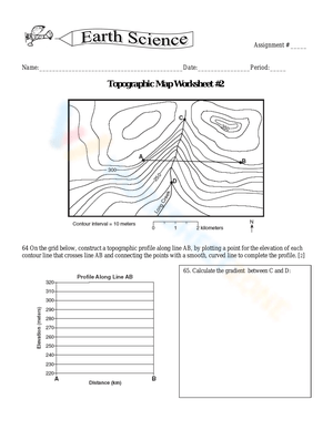
For advanced learners, extension tasks give the most traction. Ask them to sketch a simple land profile — a cross-section view — along a line drawn across a contour map. Or present two trail routes and ask them to defend in writing which route gains elevation more gradually and where each trail crosses a ridge. These tasks demand the same core skills but push students to synthesize and argue rather than just identify and label.
Standard Alignment
These worksheets align most directly with NGSS MS-ESS2-2, which asks students to construct explanations based on evidence for how geoscience processes have changed Earth's surface at varying time and spatial scales. Reading a topographic map is one of the primary tools students use to examine those spatial patterns — identifying where steep terrain accelerates runoff, where valleys follow structural features, and how landform shape relates to ongoing surface processes. The map-reading skills also support physical geography content standards in many state frameworks that address terrain interpretation, elevation, and physical feature identification at the middle school level.
Frequently Asked Questions
What background knowledge do students need before starting these worksheets?
Students should be comfortable with basic map conventions — cardinal directions, map scale, and the understanding that a map represents real physical space. Prior experience with contour maps is not required. A five-minute whole-class introduction that shows what a single contour line represents and how the contour interval works is enough to get most students started on the introductory worksheets in the set.
How long does each worksheet take to complete in class?
Most worksheets take between 15 and 25 minutes for on-level learners, depending on whether written explanation questions are included. Introductory worksheets focused on labeling and identification run closer to 15 minutes. Worksheets that include slope comparison and short written reasoning take closer to 25 minutes, especially if students trace contour lines as part of the task.
Can these worksheets be used in a geography class rather than Earth science?
Yes. The core skills — reading elevation, comparing slope, identifying physical landforms — appear in both Earth science and geography instruction at this grade level. These 6th grade topographic map worksheets pdf resources work in either setting without modification, and the map-reading skills transfer directly to physical geography units on terrain, drainage patterns, and landform classification.
Do the worksheets include answer keys?
Answer keys are included with the set. For landform identification and labeling questions, the keys show correct responses alongside brief explanations of the reasoning behind each answer — not just what to mark, but why the contour pattern indicates that particular feature. That detail makes the keys useful for teacher review and for students completing self-correction after independent practice.
Clear All