The Nordic Countries Worksheets Printable for 6th Grade Geography Lessons
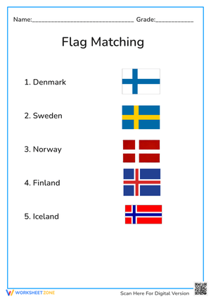
The nordic countries worksheets printable for 6th grade give teachers a focused regional geography tool at exactly the point in the middle school curriculum when students are expected to do more than name continents — they need to locate specific countries, use regional vocabulary accurately, and distinguish between overlapping geographic labels. This set concentrates on Northern Europe's five-country Nordic group: Denmark, Finland, Iceland, Norway, and Sweden. That narrow scope produces cleaner formative data than a general Europe worksheet, and it gives students enough room to actually understand a region rather than skim across it.
The Geographic Skills Each Worksheet Targets
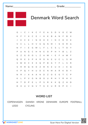
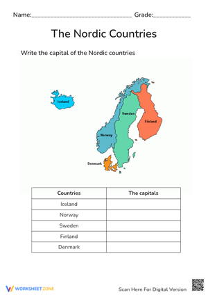
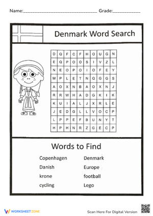
Map labeling is the core task, but each worksheet pushes past copying country names onto blank lines. Students place all five Nordic countries on an unlabeled map of Northern Europe, identify which countries share land borders, determine which is separated from the mainland by ocean, and use location language — peninsula, strait, island, region, border — in written context. That last piece matters. Sixth graders can often recite country names without being able to describe where those countries sit in relation to each other. The written location tasks push them to use geography vocabulary in sentences, not just match it to definitions on a list.
Several worksheets include a comparison component: students sort the five countries into Nordic and Scandinavian categories and explain in writing why the two terms don't carry identical meaning. Others pair map labeling with capital city matching, which adds another layer of country recognition useful when teachers review for broader Europe assessments. The full skill set across the worksheets includes:
- Labeling all five Nordic countries on an unlabeled Northern Europe map
- Identifying land borders, coastlines, and island nations within the region
- Matching each country to its capital city
- Sorting countries into Nordic vs. Scandinavian categories with written justification
- Using location vocabulary in sentences about relative position
The Nordic-Scandinavian Distinction — Why It Deserves Direct Instruction
Most 6th graders arrive treating Nordic and Scandinavian as synonyms. That confusion isn't careless — it comes from years of hearing both terms used loosely in textbooks, media, and classroom references to the same part of Europe. The distinction is small enough to explain in one short paragraph but significant enough to affect student map work: Scandinavia conventionally refers to Denmark, Norway, and Sweden, while Nordic adds Finland and Iceland to that three-country core.
The most effective way to make this distinction stick is visual and active rather than definitional. Have students first circle all five Nordic countries on their map, then go back and shade only the three that fall within the narrower Scandinavian label. That two-step action — circle, then shade — forces students to treat the two categories as distinct rather than interchangeable. Students who only read a textbook definition of the difference will often still conflate the terms two weeks later. Students who shade a map tend not to.
Errors Teachers See Most Often in These Map Tasks
The Nordic-Scandinavian conflation produces the most common error pattern: students map Denmark, Norway, and Sweden with confidence and then place Finland and Iceland as afterthoughts — or skip them entirely. But two other placement errors appear regularly enough to anticipate. Finland gets shifted eastward. Students with some prior exposure to Eastern European geography anchor Finland near the Baltic states rather than placing it along the northern coast between Norway and Russia, where it actually sits. Iceland gets compressed toward mainland Europe, clustered near Norway or Scotland rather than positioned as the westernmost point of the Nordic group, well out in the North Atlantic.
Capital cities create a second, quieter error layer. Helsinki and Oslo are the two most frequently swapped. A student who knows Helsinki is Finland's capital will still label it on Norway when moving quickly through a matching task — correct knowledge, wrong placement on the map. That pattern is worth distinguishing from a student who simply doesn't know the capital at all, because the instructional response is completely different. The worksheet format helps here because you can see exactly where each answer lands, not just whether it's marked right or wrong.
The nordic countries worksheets printable for 6th grade surface these error types efficiently because the tasks are narrow enough that a wrong answer almost always points to a specific gap — map placement, country recognition, or vocabulary confusion. A broad Europe worksheet rarely gives that kind of diagnostic clarity.
How to Build These Worksheets Into Your Lesson Planning
The strongest placement is immediately after a brief direct instruction segment — five minutes of projected map annotation and a two-minute explanation of the Nordic-Scandinavian distinction gives students enough context to work productively. That sequence applies spaced retrieval when you bring a labeling worksheet back three or four days later as a bell ringer: students attempt the labeling from memory, then check against a labeled map during whole-class review. That second pass does more for long-term placement retention than reviewing notes would.
The nordic countries worksheets printable for 6th grade also work cleanly in sub plans. A brief teacher note identifying the five Nordic countries and flagging the Nordic-Scandinavian distinction gives a substitute enough background to run a productive independent practice segment. The tasks are self-contained — students complete the map and comparison work independently, then hold discussion until the regular teacher returns.
- Bell ringer three to four days after initial instruction, using retrieval rather than notes review
- Paired work where students compare labels before whole-class correction — disagreements usually reveal the most instructive misconceptions
- Exit ticket using only the Nordic-Scandinavian sorting task, which takes about three minutes and yields immediate formative data
- Station rotation with map labeling at one station and capital city matching at another
Differentiating the Set for a Mixed-Readiness Classroom
Students still building basic map fluency get meaningful support from a word bank listing all five country names. That one adjustment removes the recall barrier without changing what's being assessed — students still have to place each country correctly on the map. For students who consistently misplace Finland or Iceland, a base map that shows surrounding bodies of water and neighboring landmasses gives them additional anchoring information without giving the answer away.
Students ready to go further can work with the broader Nordic territories — Greenland and the Faroe Islands under Denmark, Åland under Finland — as an extension prompt. A short written task asking them to argue whether Greenland should appear on a classroom map of the Nordic region adds real analytical weight without changing the worksheet format. That extension works especially well as an enrichment option during independent work time while other students are finishing the core labeling and comparison tasks.
English language learners benefit from a small illustrated glossary of the location vocabulary — peninsula, strait, island, region, border — built before the worksheet rather than encountered mid-task. The nordic countries worksheets printable for 6th grade cover a contained enough topic that vocabulary support stays practical: five countries, one region, one central distinction. That narrow scope actually makes differentiation easier to manage than it would be for a wider regional unit.
Frequently Asked Questions
Which five countries make up the Nordic region?
Denmark, Finland, Iceland, Norway, and Sweden are the five sovereign Nordic countries. For 6th grade map work, these five are the core target set. Greenland and the Faroe Islands are Danish territories, and Åland is an autonomous region under Finland — useful as extension content once students have the five-country set placed correctly on the map.
What's the difference between Nordic and Scandinavian, and do students need to know it?
Yes — it's worth a few minutes of direct instruction because the conflation is nearly universal at this level. Scandinavia conventionally refers to Denmark, Norway, and Sweden. Nordic adds Finland and Iceland. Students who carry only a Scandinavia mental map will leave Finland and Iceland out of their regional understanding, and that gap affects their map work, their written responses, and their readiness for broader Europe assessments.
How long does each worksheet typically take to complete?
Map labeling tasks take most 6th graders 8 to 12 minutes. Comparison or written explanation tasks add another 5 to 7 minutes. That timing makes each worksheet workable as a bell ringer if you assign only the labeling portion, or as a full guided practice segment when you include the sorting and written components as well.
Do students need prior geography knowledge before using these worksheets?
A basic sense of where Northern Europe sits on a world map is enough. Two or three minutes on a projected labeled map — pointing out the Nordic region and identifying the five countries — gives students the orientation they need to engage with the worksheet tasks independently. A completed Northern Europe unit isn't a prerequisite; students just need enough context to locate the region before they start labeling it on their own.
Clear All