


Views
Downloads
Essential Fold Mountain Drawing Worksheet | Grade 2
Paste this activity's link or code into your existing LMS (Google Classroom, Canvas, Teams, Schoology, Moodle, etc.).
Students can open and work on the activity right away, with no student login required.
You'll still be able to track student progress and results from your teacher account.
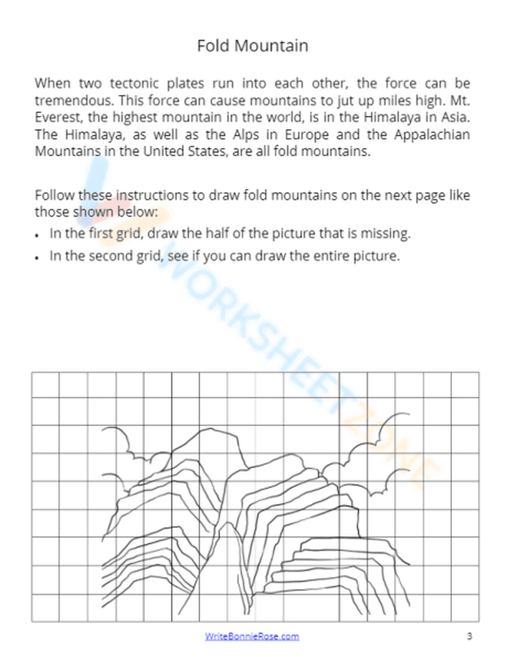
This Grade 2 Earth Science worksheet helps students visualize the formation of fold mountains through a combination of informational reading and grid-based drawing. By connecting tectonic plate movement to physical landforms, learners develop a concrete understanding of geological processes. Students will read about famous ranges like the Himalayas before practicing their observational drawing skills.
At a Glance
- Grade: 2 · Subject: Earth Science
- Standard:
2-ESS2-2— Develop a model to represent the shapes and kinds of land- Skill Focus: Illustrating fold mountains
- Format: 2 pages · 2 problems · Answer key included · PDF
- Best For: Independent science centers or sub plans
- Time: 15–20 minutes
This 2-page resource features a concise reading passage explaining how tectonic plates create fold mountains, citing real-world examples like the Alps and Appalachians. The activity includes a structured grid system to scaffold the drawing process. Students complete one symmetrical drawing and then attempt a full-scale illustration of the mountain range, supported by a clear visual reference.
This worksheet is designed for immediate classroom implementation with a total teacher prep time of under 2 minutes. Simply print the PDF and distribute it to students during your landforms unit. Because the instructions are self-explanatory and include a built-in reading component, this resource is an ideal choice for emergency sub plans or quiet morning work.
The primary focus is `2-ESS2-2`, which requires students to develop a model to represent the shapes and kinds of land and bodies of water in an area. By drawing the specific contours of fold mountains, students are creating a 2D model of a complex geological feature. This standard code can be copied directly into lesson plans, IEP goals, or district curriculum mapping tools.
Use this worksheet during the "Explain" or "Elaborate" phase of a 5E lesson on landforms. It works best after a brief discussion on tectonic plates. As a formative assessment, observe how accurately students replicate the jagged peaks in the grid; this reveals their attention to the physical characteristics that distinguish fold mountains from other land types. Expected completion time is 20 minutes.
This resource is tailored for second-grade students but is accessible for first-grade enrichment or third-grade review. It is particularly effective for visual learners and students who benefit from fine motor practice. Pair this with a physical globe or a digital map to locate the mountain ranges mentioned in the text for a more comprehensive geography lesson.
According to the RAND AIRS 2024 report on elementary science instruction, integrating literacy with visual modeling significantly improves retention of abstract geological concepts. This worksheet aligns with NGSS 2-ESS2-2 by requiring students to translate textual descriptions of tectonic forces into a visual model of fold mountains. By using a grid-based drawing system, the resource provides the necessary scaffolding for Grade 2 learners to accurately represent landform shapes. Research from Fisher & Frey (2014) emphasizes that such structured drawing tasks help bridge the gap between reading comprehension and scientific modeling. This 2-page PDF provides a structured 20-minute activity that reinforces the identification of major global mountain ranges while building foundational spatial reasoning skills. It is a reliable tool for meeting Earth Science standards in early elementary settings while maintaining high student engagement through creative expression.