Topographic Map printable worksheets for 7th Grade
These topographic map printable worksheets for 7th grade give Earth science teachers a reliable, low-setup entry point into one of the more demanding visual skills in the middle school curriculum — reading contour lines and translating a flat map into a working picture of three-dimensional terrain. Each worksheet targets a specific layer of that skill: identifying elevation values, comparing slope steepness, or naming landforms from the patterns contour lines form. The set moves students from basic symbol recognition toward actual map interpretation without requiring a technology setup or extended lesson prep.
The Specific Skills Each Worksheet Builds
Contour interpretation is not one skill — it is a cluster of related tasks that students need to practice separately before they can combine them fluently. Each worksheet in the set isolates one or two of these tasks so students build toward the full picture without getting overwhelmed by too many variables at once.
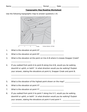
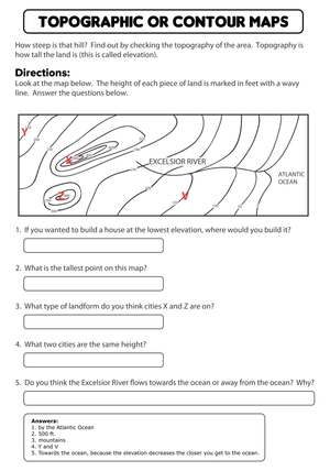
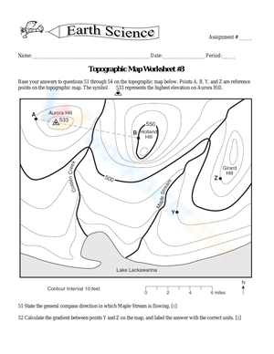
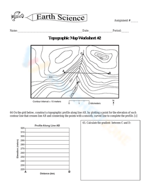
- Contour line fundamentals: Students identify that every line connects points sharing the same elevation and practice tracing individual lines to confirm that understanding before moving to any calculations.
- Contour interval reading: Students determine how much elevation separates adjacent lines by reading the map legend, then use that value to calculate elevation at unlabeled lines.
- Elevation estimation: Students infer the height of points located between index contours, which requires counting lines and applying the interval rather than just reading a printed label.
- Slope comparison: Students use line spacing — close lines for steep terrain, wider spacing for gentler grades — to rank sections of a mapped area from steepest to most gradual.
- Landform identification: Students recognize ridges, valleys, hilltops, depressions, and saddles by the characteristic shapes contour lines form around each feature.
- Relief calculation: Students find the elevation difference between the highest and lowest points on a mapped section.
- Terrain interpretation: In the most demanding items, students explain where water would likely flow across the mapped area or describe what a hiker would experience crossing a specific section.
Mistakes Students Make That These Worksheets Help You Catch
The errors students make on topographic maps are consistent enough that a teacher can anticipate them before handing anything out. The most persistent one involves ridges versus valleys. Both features produce V-shaped contour patterns, and students who memorize "V shapes mean valleys" will confidently misidentify ridges every time. The rule that actually sticks: the V points toward higher elevation for a valley and toward lower elevation for a ridge. Students need to check which direction the Vs open before labeling any feature. Saying this out loud during the first modeled example, rather than assuming students will infer it from the map alone, cuts a remarkable number of landform errors.
A second persistent error involves the contour interval itself. Many students treat the interval as the elevation assigned to the first unlabeled line rather than the elevation change between any two adjacent lines. A student might read "contour interval: 20 ft" and assign 20 feet to the lowest unlabeled contour, rather than using 20 feet as the step between each successive line. Catching this during the first guided practice prevents a calculation pattern that otherwise runs through the entire unit. A useful in-the-moment fix: ask the student to count up from a labeled index contour using the interval, line by line, rather than assigning values top-down.
Students also underestimate what "between" means spatially. A point located between two contour lines does not sit at either elevation. Students who have internalized contour reading learn to give ranges — "between 400 and 420 feet" — rather than committing to one number, and that shift in precision reflects real growth in how they handle spatial data.
Smart Ways to Work These Worksheets Into Your Week
The most consistent classroom approach is brief teacher modeling followed by partner work and then independent completion. Under a document camera, work through one elevation-identification question and one slope-comparison question aloud — narrating the decision process, not just stating the answer. That five-to-seven-minute investment up front cuts the hand-raising during independent work substantially.
When teachers use topographic map printable worksheets for 7th grade as station work, a three-station rotation organizes the skill set naturally: one station for contour interval and elevation reading, one for slope comparison and relief calculation, and one for landform identification with a short written response. Each station runs about ten minutes. Students bring completed worksheets to a brief whole-class discussion at the end — the conversation usually surfaces one or two misconceptions worth addressing before the next lesson.
One technique worth building into the routine: before students answer any questions, have them use a colored pencil to lightly trace one index contour line around the entire map. That single step slows them down enough to see that the line is continuous and marks one specific elevation — which is exactly the conceptual piece missing when students treat contour lines as general shading rather than precise elevation records. It takes about ninety seconds and reduces line-skipping errors noticeably.
Standard Alignment
The core practices in these worksheets align with NGSS MS-ESS2-2, which asks students to analyze and interpret data on the distribution and characteristics of Earth's surface features. Reading a topographic map is one of the most direct applications of that standard — students work with real geoscience data presented as a spatial visualization rather than a table or graph, which extends their data interpretation experience in a content-specific direction. The written response items also connect to RST.6-8.7, the Common Core literacy standard requiring students to integrate technical information expressed visually with their own written explanation. When a student identifies a valley and supports that identification with specific contour line direction and spacing, they are doing exactly what that standard describes. Teachers preparing students for end-of-unit Earth science assessments will find the topographic map printable worksheets for 7th grade address both the disciplinary content and the analytical literacy those assessments target.
Adjusting the Worksheets for a Range of Learners
Topographic map reading hits some 7th graders hard on first contact — particularly students who struggle with spatial reasoning or who have limited experience reading technical diagrams. The worksheets do not all need individual modification; pairing specific worksheets with student readiness levels makes the same materials work across a mixed class.
- Students who need more support: Start with worksheets that show fewer contour lines and pre-labeled elevations. Questions like "Circle the point with the highest elevation" or "Are the slopes steeper on the east or west side?" give these students something concrete to work with before they estimate anything. Keep the map simple and the question count low.
- On-level students: Assign the full skill sequence — contour interval reading, elevation estimation, slope comparison, and basic landform identification — as intended. These students benefit from the variety of question types within a single worksheet.
- Students ready for more challenge: Add a terrain profile prompt: sketch what the land would look like from a side view along a marked cross-section line. Or ask them to predict where a stream would run and justify that prediction using specific elevation values pulled from the map.
- Students developing English language skills: Pre-teaching six terms with labeled diagrams — elevation, contour line, contour interval, ridge, valley, depression — before distributing the worksheet reduces the language load without changing the science task at all.
Frequently Asked Questions
What should 7th graders be able to do with a topographic map by the end of the unit?
Students should read contour lines with enough fluency to identify specific elevations, compare slope steepness across sections of a map, and recognize common landforms by the patterns contour lines create around them. The benchmark that distinguishes solid understanding from surface-level memorization: students can write a brief explanation of what a mapped area looks like in three dimensions and support that description with evidence from the map. Students who can only name features without citing specific contour evidence have not yet reached the full target.
What order works best for introducing contour map skills?
Start with what a single contour line represents — equal elevation — before introducing the contour interval or any calculations. Once students can trace a line and state its elevation, teach them to count lines and determine elevation at unlabeled points using the interval. Slope comparison comes next. Landform identification follows, because it requires students to apply everything they have learned about elevation and spacing simultaneously. The sequence in topographic map printable worksheets for 7th grade reflects this progression, moving from single-fact reading toward analysis that requires combining multiple map clues at once.
How can I use a single worksheet for quick formative assessment?
A five-question worksheet — one elevation read, one contour interval question, one slope comparison, one landform label, and one short written explanation — gives a clear snapshot of where each student sits in the skill sequence. Scanning the class set for patterns takes about three minutes and shows exactly which part of contour interpretation needs more direct instruction the following day. That is more diagnostic than vocabulary-only review because students must work directly with the map rather than recall definitions in isolation.
Do these worksheets work in geography classes as well as science?
The topographic map printable worksheets for 7th grade transfer well to geography settings, though the instructional emphasis shifts. In Earth science, contour work connects to landform processes and surface feature formation. In geography, the emphasis falls on spatial data interpretation and real-world map literacy. The core skill — reading contour lines accurately and drawing defensible conclusions from them — is identical in both contexts, so the worksheets require no content changes when moving between departments.
Clear All