















Essential Countries Word Search | Grades 6–7 Social Studies
Paste this activity's link or code into your existing LMS (Google Classroom, Canvas, Teams, Schoology, Moodle, etc.).
Students can open and work on the activity right away, with no student login required.
You'll still be able to track student progress and results from your teacher account.
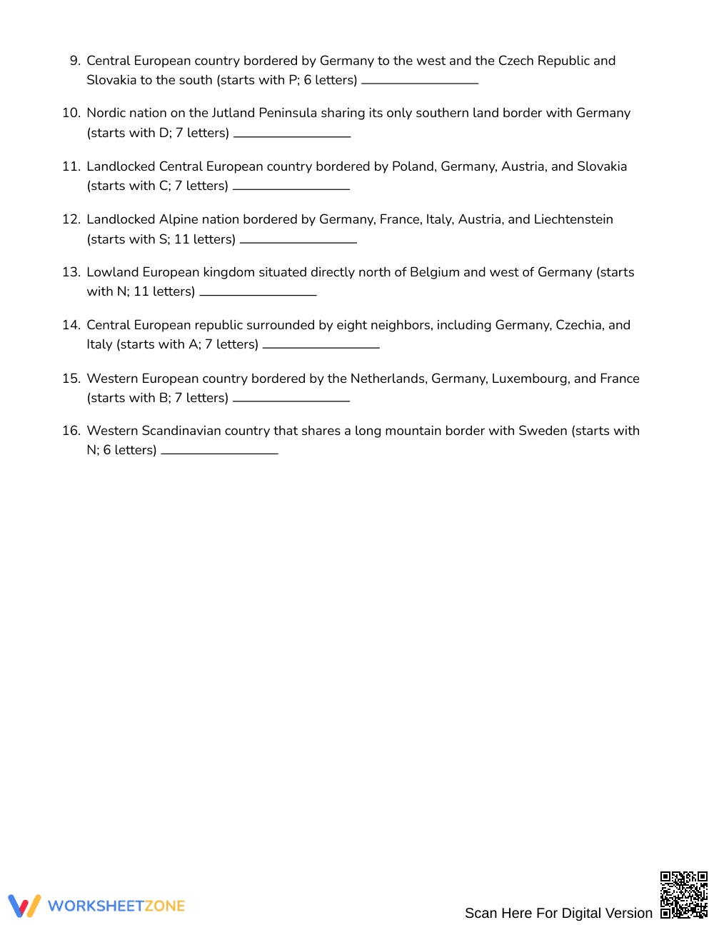
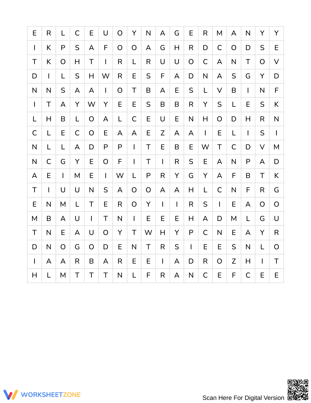
This European geography word search sharpens regional spatial awareness and country identification for middle school learners. Students analyze border clues describing neighboring nations to deduce 16 European countries and locate them across an expansive letter grid, reinforcing political geography and relational reasoning without relying on a simple word bank.
At a Glance
- Grade: Grades 6–7 · Subject: Social Studies
- Standard: Not standards-assessed — vocabulary enrichment
- Skill Focus: Country names and neighboring countries
- Format: 3 pages · 16 words · Answer key included · PDF
- Best For: European geography vocabulary review
- Time: 25–35 minutes
What's Inside
This 3-page printable resource delivers an engaging geography challenge where students solve border clues to discover 16 target European nations. Unlike standard searches, this no-bank edition requires students to deduce country names from geographic relationships before searching the grid. A thorough 4-page answer key provides clear letter highlighting for straightforward checking and self-assessment.
Puzzle Structure and Mechanics
This puzzle challenges students with an 18 × 18 letter grid containing 16 hidden European country names. Because no word bank is provided, students must read 16 descriptive clues detailing shared boundaries and regional positions to identify each nation. Words run in all 8 possible directions: north, northeast, east, southeast, south, southwest, west, and northwest.
Standards Alignment
This activity provides focused vocabulary enrichment and geographical reasoning rather than assessing a formal state standard. It strengthens cross-curricular literacy by prompting students to translate informational clues about borders into geographical nomenclature, reinforcing spatial relationships across Western, Central, Southern, and Northern Europe.
How to Use It
Introduce this activity during a European geography unit following direct instruction on regional borders, or use it after introducing political maps as an independent review task. While students work, circulate formatively to observe whether they deduce country names from clue keywords before searching or rely primarily on random letter scanning. Most students complete the activity within 25 to 35 minutes.
Who It's For
Designed for Grades 6–7 social studies students, this activity suits general education classrooms, gifted extension clusters, and early finishers who enjoy deductive logic. For students requiring additional scaffolding, consider pairing the worksheet with a blank physical or political map of Europe to support clue comprehension and spatial visualization.
Geographic literacy in middle grades relies heavily on connecting spatial vocabulary with contextual relationships. According to Fisher & Frey (2014), purposeful vocabulary acquisition improves when students engage with content-rich definitions and relational clues rather than isolated memorization lists. This Grades 6–7 geography word search targets country names and neighboring countries through 16 clue-based hidden words, prompting learners to analyze border descriptions and infer sovereign nations before locating them. By removing the traditional word bank and embedding directional constraints across an 18 by 18 matrix, the activity encourages active cognitive retrieval and reinforces spatial association between neighboring European states. The accompanying 4-page answer key ensures teachers can quickly verify student progress, making this resource an effective tool for social studies vocabulary enrichment, spatial reasoning reinforcement, and independent geographic practice across middle school classrooms.


