These 7th grade geography worksheets give teachers a set of standalone practice resources targeting the map reading, data analysis, and regional reasoning skills that middle school social studies standards require — in formats short enough to use as warm-ups but substantial enough to anchor an independent practice block. Each worksheet focuses on a specific skill area: coordinate plotting, thematic map analysis, population data, regional comparison, or human-environment interaction. That focused design means teachers can pull exactly what a given lesson needs without working through unrelated content first.
Skills These Worksheets Build
Geography at seventh grade asks students to work with visual and written information at the same time, which makes skill sequencing matter. Each worksheet in the set targets a focused area rather than sampling geography broadly, so students practice one thing well before moving to the next.
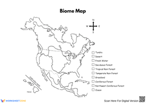
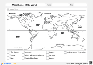
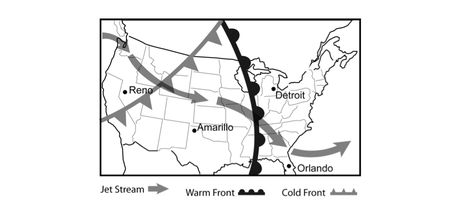
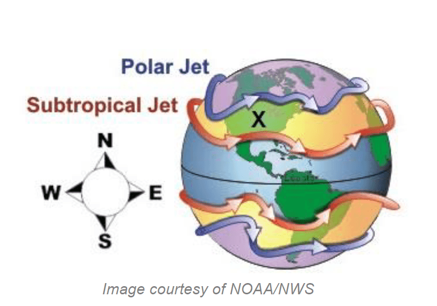
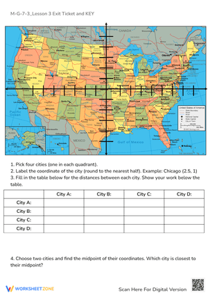
- Map and atlas skills: locating coordinates, interpreting a compass rose and intermediate directions, applying map scale to estimate distance, reading legends and symbols, and distinguishing thematic map types including choropleth and dot density formats.
- Physical geography: identifying major landforms and climate zones, explaining how physical features shape settlement and movement, and connecting natural resource distribution to economic patterns.
- Human geography: population density, migration push and pull factors, urbanization, and cultural diffusion across regions.
- Regional comparison: identifying formal and functional regions, comparing them using map evidence and short informational text, and constructing brief written responses with textual support.
- Data interpretation: reading population tables, climate graphs, and migration charts alongside targeted questions that require students to move from observation to explanation.
That last category deserves emphasis. A worksheet asking students to read a bar graph and circle the highest value is identification work. Solid 7th grade geography worksheets consistently push students to explain what the pattern suggests — why that population spike occurs, what geographic factor might drive it. That analytical shift is where seventh-grade thinking needs to land, and it is what separates meaningful practice from busywork.
Mistakes Students Make That These Worksheets Help You Catch
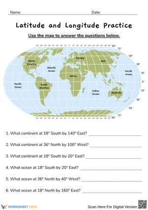
The most durable confusion in map skills at this level is the latitude-longitude direction error. Students learn that latitude lines run horizontally across the globe and then conclude, logically but incorrectly, that latitude measures east-west position. The correction — that horizontal lines measure north-south distance from the equator — rarely sticks after a single explanation. When 7th grade geography worksheets require students to plot a coordinate, label its hemisphere, and then write a sentence describing the location, they surface this error during practice rather than on an assessment, when it is still easy to address.
Physical geography produces its own consistent error: students treat climate as a description of current conditions rather than a long-term pattern. An answer like "this region has a tropical climate because it is hot and rainy" is partially right but conceptually incomplete. Worksheets built around twelve-month climate graphs rather than single-snapshot descriptions force the distinction in a way that a vocabulary definition never quite does. In human geography work, students reading choropleth population maps routinely misread darker shading as representing more people total rather than higher density per square kilometer — a misread that a single targeted question can surface in under two minutes of independent work, long before it causes problems on a unit test.
Recommended Lesson-Planning Strategies for These Worksheets
The most reliable classroom use is the mini-lesson follow-up. Teach the concept — say, how to interpret a dot density map — and immediately hand students a worksheet that applies it. That sequence reduces the reteaching needed the next day because students encode the skill while the instruction is still fresh. Bell-ringer use works well for map skills in particular: one map or one graph with three focused questions fills the 8 to 10 minutes after morning announcements and activates prior knowledge before direct instruction begins.
Station rotation is another strong fit. Three stations — map analysis, chart or graph reading, and a short constructed-response task — rotate students through different geographic thinking modes in a single period. For sub plans, any worksheet with self-contained visuals and predictable question formats runs without the substitute needing to explain background context. One practical upgrade: adding a transfer question at the end — What geographic factor might explain this pattern? or Where else in the world would you expect this to occur? — raises the cognitive demand without adding meaningful grading time. A set of worksheets used consistently this way becomes a formative assessment thread woven across units rather than isolated review.
Adapting the Set for Mixed-Ability Classrooms
Most seventh-grade classrooms hold students who can already draw inferences from a thematic map and students who are still working out cardinal directions reliably. The same worksheet can serve both groups with deliberate but limited adjustment — no need to create entirely separate assignments.
Pre-teaching three or four key terms before distributing a worksheet — density, migration, climate zone, urbanization — removes the vocabulary barrier without giving away the geographic thinking. Sentence frames for written responses (The data shows... which suggests... or This region differs because...) help students who have the content knowledge but freeze at a blank prompt. For advanced learners, an open-ended extension question added to the end — Where else in the world would you expect to see a similar pattern, and why? — keeps them working without requiring a separate task. Students who struggle with the visual density of a printed map often do better with digital annotation tools that let them zoom in and highlight features directly on screen.
Standard Alignment
The worksheets align with the National Geography Standards, specifically Standard 1 (using maps and geographic representations to analyze spatial relationships), Standard 4 (the physical and human characteristics of places), and Standard 9 (the characteristics, distribution, and migration of human populations on Earth's surface). In practical classroom terms, Standard 1 covers the map skills most teachers front-load in the first unit of the year; Standards 4 and 9 deepen through regional study as the semester progresses. The set also supports CCSS.ELA-LITERACY.RH.6-8.7, which addresses integrating visual information — maps, charts, and graphs — with written text. Geography instruction naturally builds this literacy standard across every unit without needing to treat it as a separate ELA objective.
Frequently Asked Questions
How long does each worksheet take to complete?
Most run 10 to 18 minutes for on-level students. Map skills worksheets with coordinate plotting tend toward the shorter end. Regional comparison tasks that include a short reading passage and a written response question run closer to 18 minutes. That range fits a bell-ringer slot, a mini-lesson practice block, or a focused review period without running over.
Do these work in digital classrooms, or are they formatted only for print?
Both formats work. Maps and charts are readable at standard screen sizes, and the question types — labeled diagrams, short answer, and brief constructed response — transfer without issue to most learning management systems. Many teachers find that assigning 7th grade geography worksheets through Google Classroom or a similar platform gives students the option to annotate maps directly, which adds interaction that print does not offer.
What about students who are reading below grade level?
The visual components carry much of the content load. A well-designed thematic map or population graph communicates core information without requiring students to decode dense text first. Pre-teaching vocabulary before students begin makes the biggest difference: students who understand what urbanization and density mean before they start answer geographic questions more accurately than students who encounter the terms mid-task and stall.
Do the worksheets cover physical and human geography equally?
The set covers both. Physical geography worksheets address landforms, climate zones, natural resources, and how physical features relate to human settlement patterns. Human geography worksheets address population, migration, culture, and land use. Several worksheets integrate both within a regional comparison task — and that combined format tends to be where the most complex geographic thinking happens at this level, which also mirrors how state assessments typically frame geography questions for middle school students.