


























Views
Downloads



Latitude & Longitude Worksheet | Grade 6 Essential
Paste this activity's link or code into your existing LMS (Google Classroom, Canvas, Teams, Schoology, Moodle, etc.).
Students can open and work on the activity right away, with no student login required.
You'll still be able to track student progress and results from your teacher account.
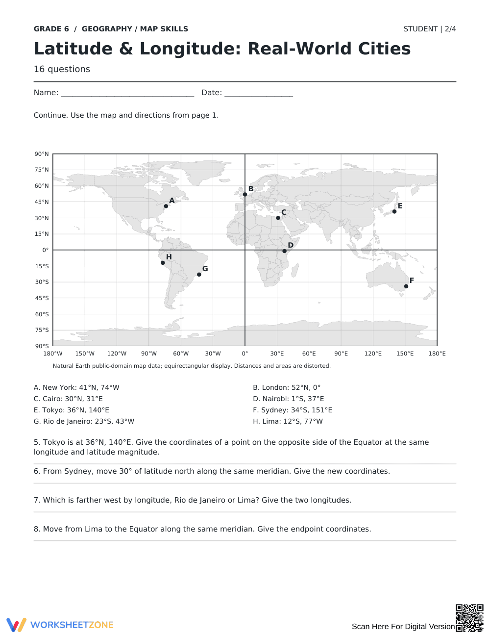
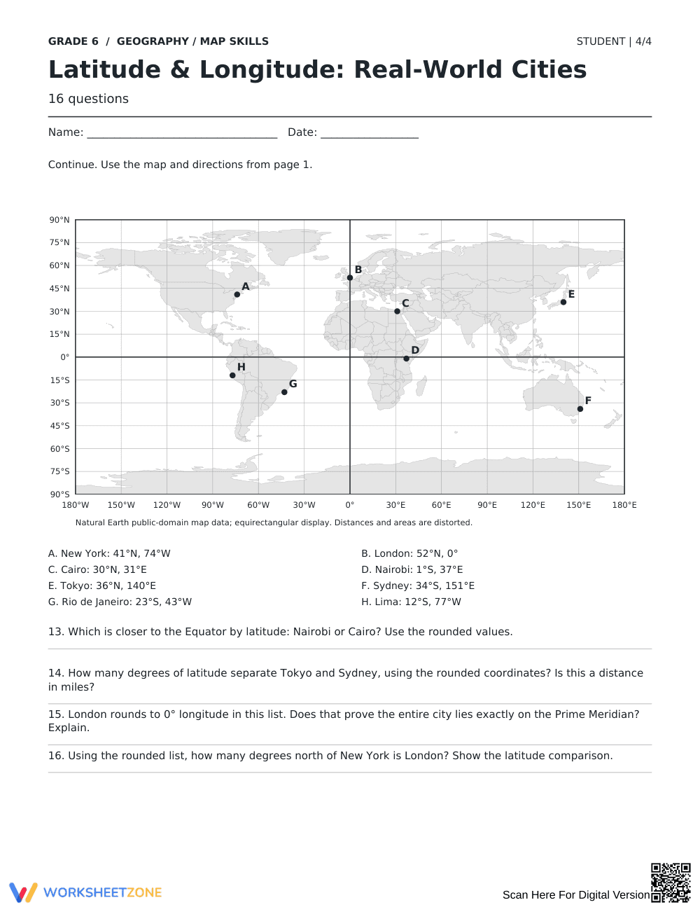
This Grade 6 geography worksheet strengthens global spatial understanding by training students to read and apply latitude and longitude coordinates. Learners locate eight world cities on an equirectangular map, track coordinate shifts across hemispheres, and calculate angular distances to build geographic literacy.
At a Glance
- Grade: 6 · Subject: Geography & Map Skills
- Standard:
D2.Geo.1-3.6-8— Construct and use maps to display spatial relationships and identify absolute location coordinates- Skill Focus: Latitude and longitude coordinates, hemispheres, and spatial orientation
- Format: 4 pages · 16 problems · Answer key included · PDF
- Best For: Independent practice, geography lab, homework
- Time: 35–45 minutes
What's Inside
This 4-page printable resource features 16 focused questions organized around an equirectangular world map projection and an eight-city coordinate list. Students identify locations including Tokyo, London, Nairobi, and Lima. The layout provides labeled reference markers, coordinate degree grids, lined response areas, and a 2-page teacher answer key with complete explanations.
Skill Progression
- Guided practice (Questions 1–4): Students pair given coordinates with map letters and evaluate single-axis movement along meridians toward the Equator.
- Supported practice (Questions 5–8): Students determine antipodal coordinates across hemispheres, calculate 30-degree latitudinal shifts, and compare longitudinal positions between western cities.
- Independent practice (Questions 9–16): Students categorize quad-hemisphere placements, compute coordinate translations, evaluate map distortion, and assess Prime Meridian alignment.
This sequence follows a gradual-release model, progressing from direct coordinate matching to multi-step spatial calculations.
Standards Alignment
This worksheet aligns directly to primary standard `D2.Geo.1-3.6-8`: "Construct maps and other graphic representations of both familiar and unfamiliar places by using correct geographic representations, coordinate systems, and spatial perspectives." The exercises also support `CCSS.ELA-LITERACY.RH.6-8.7` by requiring students to integrate quantitative coordinate data with a visual map display. Both standard codes can be copied directly into lesson plans, IEP goals, or district curriculum mapping tools.
How to Use It
Use this worksheet after direct instruction on parallels and meridians, or assign it during station rotations. During practice, check whether students reverse latitude and longitude order when writing coordinates. Expected completion time is 35 to 45 minutes.
Who It's For
This printable suits Grade 6 social studies classes and middle school geography courses. For differentiated support, pair it with a classroom globe or an illustrated cardinal directions anchor chart.
Middle school geography instruction requires rigorous practice with coordinate systems to cultivate spatial reasoning and geographic literacy. Aligned with standard D2.Geo.1-3.6-8, this resource develops student proficiency in reading latitude and longitude coordinates to determine absolute location across global map projections. Grounded in the gradual release of responsibility framework synthesized by Fisher & Frey (2014), the instructional sequence guides learners through structured modeling, shared geographic analysis, and autonomous problem solving. By translating abstract coordinate degrees into real-world geographic positions, students build mental models of global hemispheres, meridians, and directional shifts. Empirical findings in spatial education confirm that combining visual cartographic representations with quantitative coordinate analysis significantly improves geographic data interpretation over isolated rote memorization. Consequently, this four-page worksheet provides an essential instructional bridge between conceptual grid instruction and real-world spatial application in secondary social studies curricula.


