


















Views
Downloads



Latitude & Longitude Printable Worksheet | Grade 6
Paste this activity's link or code into your existing LMS (Google Classroom, Canvas, Teams, Schoology, Moodle, etc.).
Students can open and work on the activity right away, with no student login required.
You'll still be able to track student progress and results from your teacher account.
This 5-page geography worksheet builds middle school students' mastery of global coordinates through 25 structured problems. Learners read, plot, and analyze latitude and longitude points on world maps, developing spatial reasoning and cartographic literacy. Targeted questions connect grid mechanics to conceptual understanding across core social studies curricula.
At a Glance
- Grade: 6 · Subject: Geography & Map Skills
- Standard:
D2.Geo.1-3.6-8— Use map coordinates to locate places and analyze spatial relationships- Skill Focus: Latitude, longitude, hemisphere classification, and coordinate plotting
- Format: 5 pages · 25 problems · Answer key included · PDF
- Best For: Mid-unit review and assessment
- Time: 40–50 minutes
What's Inside
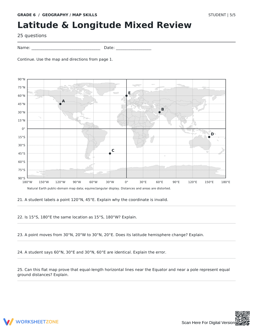
This 5-page packet features 25 problems using equirectangular world maps with 15-degree latitude and 30-degree longitude intervals. Students read coordinate points, plot locations, identify hemispheres, track distance along parallels, and complete five error-analysis explanations. A complete 3-page answer key provides visual map plots and scoring criteria.
Skill Progression
- Guided practice (Problems 1–5): Students read labeled points on a global grid to write exact coordinates with hemisphere notations.
- Supported practice (Problems 6–15): Learners plot new coordinates, identify northern/southern/eastern/western hemispheres, and apply baseline rules for the Equator and Prime Meridian.
- Independent practice (Problems 16–25): Students calculate degree distances, shift along meridians, and analyze coordinate errors and map distortion.
This sequence follows a gradual-release framework from basic plotting to analytical reasoning.
Standards Alignment
This resource aligns with C3 Framework standard `D2.Geo.1-3.6-8` by having students construct and interpret map grids to explain locations. It also supports `CCSS.ELA-LITERACY.RH.6-8.7` through integrating visual map data with written explanations. Both standard codes can be copied directly into lesson plans, IEP goals, or district curriculum mapping tools.
How to Use It
Use this worksheet after direct instruction on geographic coordinates, or distribute pages across multi-day review stations. For formative assessment, check student explanations on Problems 21 through 24 to detect coordinate-order reversals or hemisphere misconceptions. The 25-question review requires 40 to 50 minutes of instructional time.
Who It's For
This activity is designed for Grade 6 geography learners and older students needing map grid remediation. Teachers can differentiate by highlighting reference axes for struggling students or assigning nautical calculations to advanced learners. Pair this resource with physical globes or atlas lessons for maximum impact.
Under C3 Framework standard D2.Geo.1-3.6-8, middle school geography students must master coordinate grids to locate places, track movement, and analyze spatial relationships on maps. Research synthesized by Fisher & Frey (2014) on the gradual release of responsibility demonstrates that spatial skill acquisition increases significantly when practice transitions from guided identification to independent conceptual explanation. This 25-item mixed review implements that instructional architecture by guiding students from basic coordinate reading through independent error analysis and projection critique. Students not only identify absolute locations using standard hemisphere notation, but also explain why specific coordinates are invalid and how flat maps distort distances near polar regions. By combining quantitative grid tracking with written reasoning, this resource ensures learners develop durable spatial analysis habits that transfer directly to advanced geography coursework, standardized social studies assessments, and everyday cartographic interpretation.


