



























Views
Downloads

Printable Biome Map Coloring Worksheet | Grade 6 Science

Paste this activity's link or code into your existing LMS (Google Classroom, Canvas, Teams, Schoology, Moodle, etc.).
Students can open and work on the activity right away, with no student login required.
You'll still be able to track student progress and results from your teacher account.
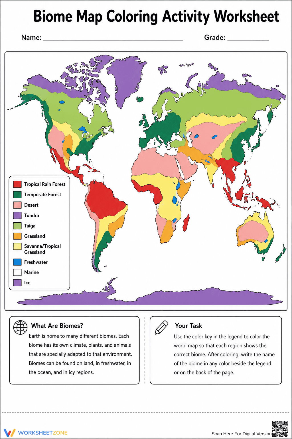
This printable world biomes map coloring activity helps students visually identify and locate ten major global ecosystems. By matching the color key to specific geographic regions, learners build foundational knowledge of how climate and geography shape plant and animal life across the planet.
At a Glance
- Grade: 6 · Subject: Science
- Standard:
MS-ESS2-6— Model how Earth's circulation patterns determine regional climates.- Skill Focus: Mapping Global Biomes
- Format: 1 page · 10 map regions · Answer key included · PDF
- Best For: Independent practice or centers
- Time: 15–20 minutes
This single-page resource features a clear, unlabeled world map alongside a comprehensive ten-item color legend. Students will find designated areas for tropical rainforests, temperate forests, deserts, tundra, taiga, grasslands, savannas, freshwater, marine, and ice biomes. A brief introductory text box defines what a biome is, while a task box provides explicit instructions for completing the map.
- Print (1 minute): Simply print the PDF map and ensure students have access to colored pencils or crayons matching the ten legend categories.
- Distribute (1 minute): Hand out the worksheet as a standalone activity or alongside a textbook reading on global ecosystems.
- Review (3 minutes): Use the included answer key to quickly verify that students have accurately color-coded the major geographic regions.
With under two minutes of total teacher prep time, this activity is an excellent addition to any emergency sub plan.
Aligned to MS-ESS2-6, this activity supports students as they develop and use a model to describe how unequal heating and rotation of the Earth cause patterns of atmospheric and oceanic circulation that determine regional climates. Recognizing these climate-driven biomes is a crucial step in understanding global ecosystems. Both standard codes can be copied directly into lesson plans, IEP goals, or district curriculum mapping tools.
Use this coloring map during direct instruction as a guided visual aid while introducing the concept of regional climates and ecosystems. Alternatively, assign it as an independent review task after a unit on animal adaptations to help students visualize where specific species might live. As a formative assessment, observe whether students can correctly identify the equatorial placement of tropical rainforests versus the polar locations of tundra and ice. Expect completion to take 15 to 20 minutes.
This worksheet is designed for middle school science and geography students learning about global ecosystems. The visual nature of the coloring task provides built-in differentiation for English Language Learners and visual learners who benefit from spatial representation over text-heavy assignments. Pair this map with a direct instruction lesson on climate zones or a research project on specific animal adaptations.
Integrating visual mapping tasks into middle school science curricula significantly enhances spatial reasoning and retention of complex ecological concepts. When students actively color and label geographic regions, they transition from passive reading to active modeling of Earth's systems. This aligns directly with MS-ESS2-6, requiring learners to model how Earth's circulation patterns determine regional climates. According to Fisher & Frey (2014), incorporating multimodal learning strategies, such as combining text-based legends with visual map coloring, improves cognitive processing and long-term memory retrieval for foundational vocabulary. By physically mapping ten distinct biomes—from equatorial rainforests to polar ice caps—students build a concrete mental framework necessary for advanced environmental science topics. This hands-on approach ensures learners can accurately visualize the global distribution of ecosystems before analyzing the specific biological adaptations required to survive within them.


