


Views
Downloads
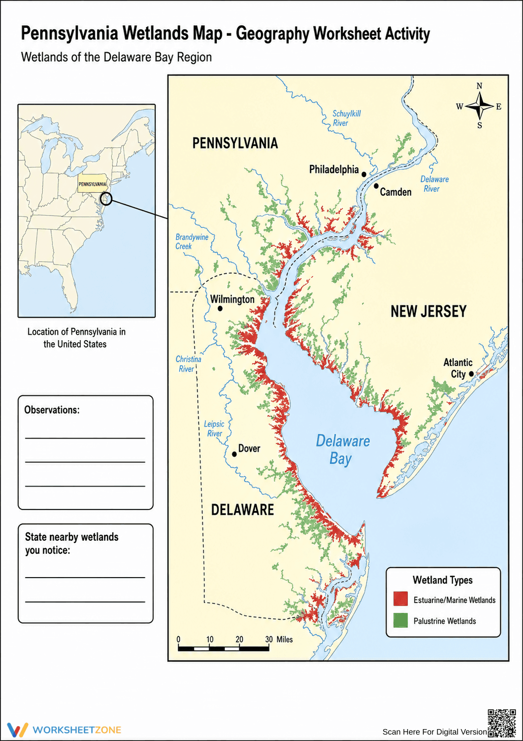
Grade 2 Wetlands Map — Printable Geography Worksheet
Paste this activity's link or code into your existing LMS (Google Classroom, Canvas, Teams, Schoology, Moodle, etc.).
Students can open and work on the activity right away, with no student login required.
You'll still be able to track student progress and results from your teacher account.
This Grade 2 science worksheet helps students develop foundational map-reading skills by observing wetland habitats in the Delaware Bay region. By analyzing a detailed map and legend, young learners identify different types of wetlands and record their geographical observations directly on the page.
At a Glance
- Grade: 2 · Subject: Science
- Standard:
2-ESS2-2— Identify shapes and kinds of land and water- Skill Focus: Map reading and habitat observation
- Format: 1 page · 2 tasks · No answer key · PDF
- Best For: Independent practice or center work
- Time: 15–20 minutes
This single-page resource features a full-color map of the Delaware Bay region, highlighting estuarine and palustrine wetlands across Pennsylvania, New Jersey, and Delaware. It includes a clear map key, a compass rose, a scale, and an inset map showing the region's location within the United States. Two structured response boxes prompt students to write down their geographical observations and identify nearby wetland areas.
- Print (1 minute): Simply print the color or grayscale PDF. No special materials are required.
- Distribute (1 minute): Hand out the maps to students along with pencils for recording their findings.
- Review (3 minutes): Briefly discuss the map key and compass rose as a class before students begin.
Total teacher prep time is under two minutes, making this an excellent resource for quick science centers or emergency substitute plans.
Aligned to 2-ESS2-2, this activity supports students as they develop models or use maps to represent the shapes and kinds of land and bodies of water in an area. It also touches on early habitat recognition. Both standard codes can be copied directly into lesson plans, IEP goals, or district curriculum mapping tools.
Use this map activity during a unit on Earth's systems or animal habitats. It works perfectly as an independent center activity after a direct instruction lesson on reading map keys. As a formative assessment tip, observe whether students correctly use the legend to distinguish between the two types of wetlands when writing their observations. Expect students to complete the tasks in 15 to 20 minutes.
This resource is designed for second-grade students learning basic geography and earth science concepts. The visual nature of the map provides built-in differentiation for visual learners and English Language Learners. Pair this worksheet with a picture book about wetland ecosystems or a direct instruction lesson on reading compass roses and map scales.
Integrating visual data tools like maps into early elementary science instruction significantly enhances spatial reasoning and environmental awareness. When students engage with standard 2-ESS2-2 to identify shapes and kinds of land and water, they build critical foundational skills for later geographical studies. According to Fisher & Frey (2014), providing students with structured, visually rich graphic organizers and maps supports deeper cognitive processing and better retention of complex vocabulary. This map reading and habitat observation activity allows young learners to connect abstract ecological concepts to concrete geographical representations. By analyzing the distribution of wetlands in a specific region, students move beyond simple memorization to active inquiry, fostering a stronger understanding of how landforms and water bodies interact within local ecosystems.