


Views
Plays


Africa Map Labeling Worksheet | Grade 6 Printable
Paste this activity's link or code into your existing LMS (Google Classroom, Canvas, Teams, Schoology, Moodle, etc.).
Students can open and work on the activity right away, with no student login required.
You'll still be able to track student progress and results from your teacher account.
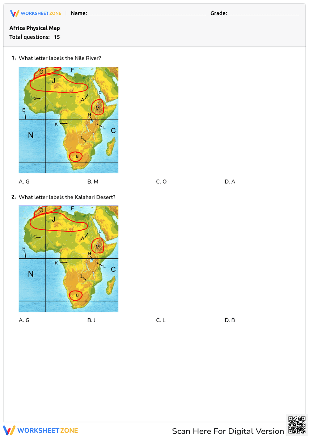
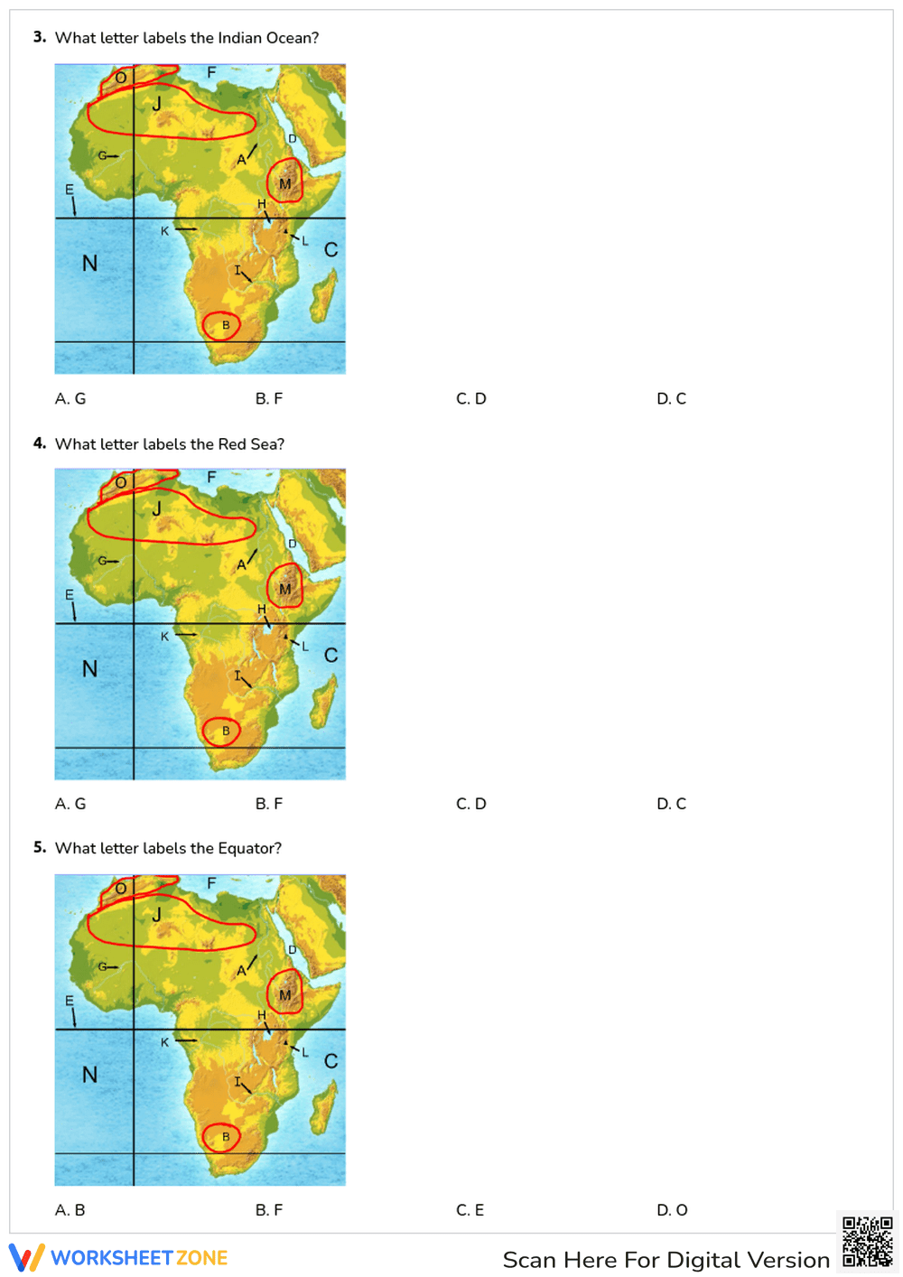
This Grade 6 and 7 geography worksheet helps students master the physical landscape of Africa by identifying key landforms and bodies of water. Through a structured map-reading exercise, learners will locate major rivers, deserts, mountains, and oceans, building essential spatial awareness and regional geographic knowledge.
At a Glance
- Grade: 6 · Subject: Geography
- Standard:
TEKS 6.4(B)— Identify and locate major physical geographic features on a map.- Skill Focus: Map Labeling & Spatial Awareness
- Format: 6 pages · 15 problems · Answer key included · PDF
- Best For: Independent practice or assessment
- Time: 15–20 minutes
This comprehensive resource features 15 multiple-choice questions spread across 6 pages. Each question presents a clear, color-coded physical map of Africa with specific regions marked by letters. Students must match the correct letter to prominent geographical features, including the Nile River, Sahara Desert, Mount Kilimanjaro, and the Indian Ocean. A complete answer key is provided to ensure quick and accurate grading.
Designed for maximum efficiency, this zero-prep resource follows a simple three-step workflow. First, print the PDF (1 minute). Second, distribute the packets to your students (1 minute). Third, review the answers together using the included key or collect them for a quick grade (5 minutes). With under two minutes of total teacher prep time, this activity is an ideal, self-explanatory assignment for a substitute teacher plan or a busy afternoon.
This activity is tightly aligned to TEKS 6.4(B), requiring students to identify and locate major physical and human geographic features such as landforms, water bodies, and urban centers of various places and regions. It also supports general middle school spatial reasoning standards by reinforcing map-reading skills. Both standard codes can be copied directly into lesson plans, IEP goals, or district curriculum mapping tools.
Use this worksheet as a formative assessment after direct instruction on the geography of Africa to gauge student retention of key locations. Alternatively, it serves as an excellent independent practice activity during a station rotation. As a formative assessment observation tip, watch to see if students can quickly differentiate between the major rivers (like the Nile and Congo) versus the surrounding oceans, which indicates strong foundational map literacy. Expect students to complete the task within 15 to 20 minutes.
This resource is primarily designed for 6th and 7th-grade social studies students studying world geography. The visual nature of the multiple-choice map format provides built-in scaffolding, making it accessible for English Language Learners and students needing visual accommodations. It pairs perfectly with an introductory direct instruction lesson on African biomes or a physical geography anchor chart.
Mastering spatial awareness through targeted map practice is a critical component of middle school social studies. This resource aligns with TEKS 6.4(B), focusing on the ability to identify and locate major physical geographic features on a map. According to a recent EdReports 2024 analysis, students who engage in repeated, visually supported map-reading exercises demonstrate a significantly higher retention rate of regional geographic knowledge compared to those using text-based descriptions alone. By requiring learners to repeatedly interact with the same map to locate different features—from the Atlas Mountains to the Kalahari Desert—this worksheet reinforces cognitive mapping skills. The multiple-choice format reduces cognitive overload, allowing students to focus entirely on spatial relationships rather than spelling or recall fatigue, ensuring a highly effective and research-backed learning experience for all middle school geography students.