


Views
Plays
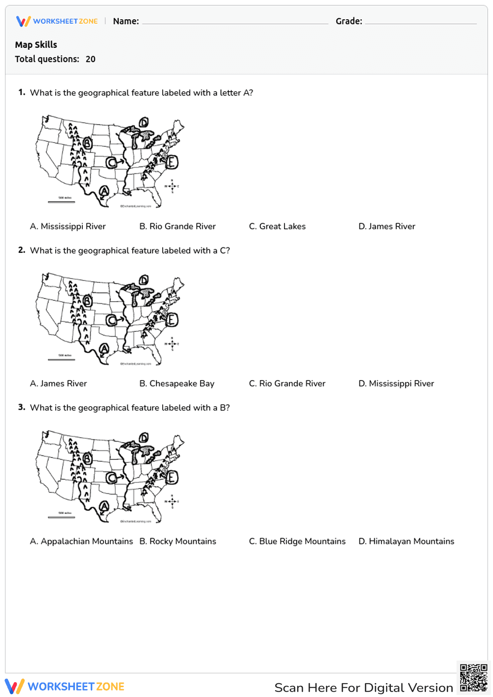


Grade 9-10 Geography Maps — Printable No-Prep Worksheet
Paste this activity's link or code into your existing LMS (Google Classroom, Canvas, Teams, Schoology, Moodle, etc.).
Students can open and work on the activity right away, with no student login required.
You'll still be able to track student progress and results from your teacher account.
This Grade 9-10 geography worksheet gives students targeted practice identifying major physical features, continents, and oceans. By completing this map skills assessment, students will strengthen their spatial awareness and geographic vocabulary, ensuring they can accurately locate key global and regional landmarks on various map projections.
At a Glance
- Grade: 9-10 · Subject: Geography
- Standard:
NCSS.D2.Geo.1.9-12— Use maps to analyze spatial patterns and locations- Skill Focus: Map Identification
- Format: 5 pages · 20 problems · PDF
- Best For: Formative assessment or sub plans
- Time: 20–30 minutes
What's Inside
This comprehensive resource features 20 multiple-choice questions spread across five pages. Students will analyze labeled maps of the United States and the world to identify specific rivers, mountain ranges, continents, and oceans. The clear, high-contrast map graphics ensure students can easily distinguish between different regions, while the multiple-choice format allows for quick and objective grading.
Zero-Prep Workflow
- Print (1 minute): Simply print the five-page PDF assessment for each student.
- Distribute (1 minute): Hand out the copies at the beginning of the lesson or leave them in a substitute teacher folder.
- Review (5 minutes): Collect the completed quizzes and grade them rapidly using the straightforward multiple-choice format. Total teacher prep time is under two minutes, making this an ideal zero-prep solution for busy educators.
Standards Alignment
Aligned to NCSS.D2.Geo.1.9-12, this worksheet requires students to use maps and other geographic representations to analyze spatial patterns of familiar and unfamiliar places. It also supports general spatial reasoning skills necessary for high school social studies. Both standard codes can be copied directly into lesson plans, IEP goals, or district curriculum mapping tools.
How to Use It
Pre-Assessment: Administer this quiz before beginning a global geography unit to establish baseline knowledge of continents, oceans, and major US landforms. Expected completion time is 20 to 30 minutes.
Substitute Teacher Plan: Keep a class set of this self-explanatory worksheet in your emergency sub folder. It requires no prior direct instruction and keeps students engaged in meaningful academic work. While students work, observe their ability to differentiate between the Equator and Prime Meridian to identify areas needing review.
Who It's For
This resource is designed for 9th and 10th-grade geography or world history students. It serves as an excellent foundational review for general education classrooms and provides clear, visual scaffolding for English Language Learners (ELLs) developing their academic vocabulary. Pair this worksheet with a large classroom wall map or a digital interactive map activity to reinforce the locations covered in the quiz.
Integrating map identification tasks into high school social studies is crucial for developing spatial literacy. Aligned with NCSS.D2.Geo.1.9-12, this resource helps students use maps to analyze spatial patterns and locations effectively. According to a RAND AIRS 2024 report, students who regularly engage with visual geographic representations demonstrate significantly higher retention of historical and political contexts compared to those who only read text-based descriptions. By practicing these foundational map skills, learners build the necessary cognitive frameworks to understand complex global interactions, trade routes, and geopolitical boundaries.