


Views
Plays
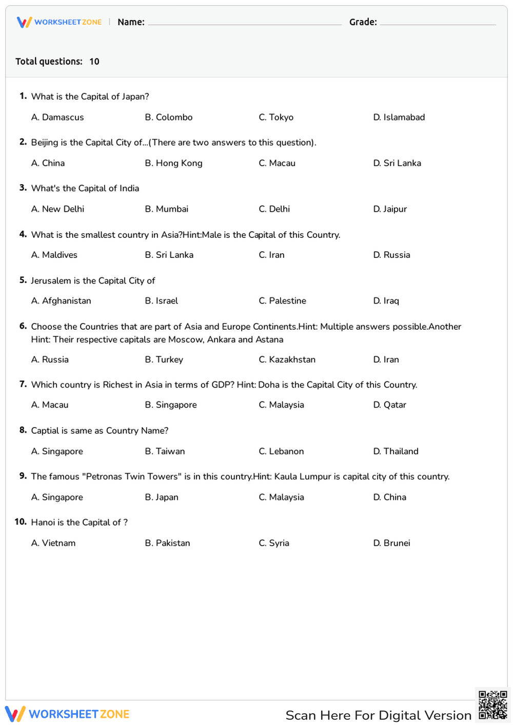
Printable Asia Geography Quiz: Countries & Capitals
Paste this activity's link or code into your existing LMS (Google Classroom, Canvas, Teams, Schoology, Moodle, etc.).
Students can open and work on the activity right away, with no student login required.
You'll still be able to track student progress and results from your teacher account.
This Grade 3-5 geography worksheet provides a comprehensive review of the Asian continent through 10 targeted multiple-choice questions. Students identify major capitals, recognize transcontinental nations, and recall specific regional facts. It serves as an efficient assessment tool for political geography units, ensuring students can accurately locate and name key sovereign states across Asia.
At a Glance
- Grade: 3-5 · Subject: Social Studies
- Standard:
SS.3.G.1.1— Use maps and geographic representations to identify political features of continents- Skill Focus: Asian Countries and Capitals
- Format: 1 page · 10 problems · Answer key included · PDF
- Best For: Quick formative assessment or geography review
- Time: 10–15 minutes
The worksheet features a clean, single-page layout containing 10 multiple-choice questions. Each question includes four options (A-D) and covers a variety of geographic concepts, including capital cities like Tokyo and Hanoi, the smallest country in Asia, and the identification of transcontinental countries like Russia and Turkey. Hints are provided within the questions to support student recall and critical thinking.
This resource is designed for a seamless classroom experience. First, print the single-page PDF for your entire class in less than 60 seconds. Next, distribute the worksheet as a bell ringer or exit ticket; students typically complete the 10 questions in approximately 12 minutes. Finally, review the answers as a whole group to clarify misconceptions about regional borders or economic facts. Total teacher preparation time is under 2 minutes, making it an ideal choice for substitute lesson plans.
This resource aligns with SS.3.G.1.1, which focuses on identifying political features of the world's continents. It also supports broader geography standards regarding the spatial organization of people and places. By requiring students to distinguish between countries and their respective capitals, the worksheet reinforces the concept of political boundaries and national identity. This standard code can be copied directly into lesson plans, IEP goals, or district curriculum mapping tools.
Use this worksheet as a mid-unit check during a study of world continents. Before direct instruction, assign it as a pre-assessment to gauge prior knowledge of Asian geography. During the lesson, use question 6 to spark a discussion about transcontinental countries and how borders are defined. A formative observation tip: watch for students who struggle with the multiple-choice hints, as this indicates a need for further instruction on complex political entities. Expected completion time is 10 to 15 minutes.
This worksheet is ideal for upper elementary students in grades 3, 4, and 5 who are exploring global geography. It is particularly effective for visual learners who benefit from clear, structured text. For differentiation, pair this quiz with a physical map of Asia or an interactive atlas. It serves as a natural companion to units on world cultures, international trade, or regional landmarks like the Petronas Twin Towers.
Geography education in the elementary years is critical for developing a student's global perspective. This worksheet utilizes the SS.3.G.1.1 standard to ensure students can identify political features of the Asian continent, a foundational requirement for later social studies mastery. According to the RAND AIRS 2024 report, frequent low-stakes retrieval practice, such as this 10-question quiz, significantly improves long-term retention of factual geographic data compared to passive reading alone. By focusing on specific capitals like Tokyo, New Delhi, and Doha, the resource builds a mental map that supports future cross-curricular connections. The inclusion of transcontinental facts further challenges students to think beyond simple borders, aligning with modern pedagogical shifts toward complex global literacy. This structured approach ensures that Grade 3-5 learners meet essential benchmarks while maintaining high engagement.