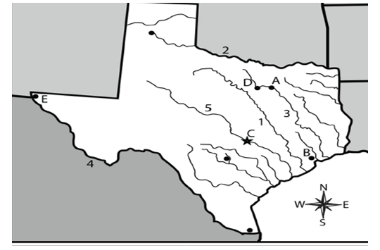
Which letter on the map represents the North Central Plains region: B. Which letter on the map represents the Coastal Plains region: A. Which letter on the map represents the Mountains and Basins region: D. Which letter represents the Great Plains region: C. What region of Texas do you travel to if you want to go camping in Big Bend National Park: Mountain and Basin. Which region is the highest in elevation, very dry with deep canyons: Mountain and Basins. Which region of Texas has the most urban and cultural centers: Coastal Plains. Which region of Texas contains the Piney Woods, Post Oak Belt and the city of Houston: Coastal Plains. If you travel from east to west across the state of Texas which of the following statements is true: You move from low elevation to higher elevation.. Which city on the map is marked with the letter A: Dallas. Which city on the map is marked by the letter C: Austin. Which city on the map is marked by the letter E: El Paso. Which river is represented on the map by the number 2: Red River. Which river is represented on the map by the 4: Rio Grande. How does the physical environment of coastal Texas compare with that of the Mountain and Basin region: Coastal Texas has more rivers. Why do historians divide the past into eras: They want to group similar events for the convenience of studying them.. Which of the following is not a region of Texas: Pacific Plains. What impact did the artifacts shown have on native Texans ability to settle in one location: These objects allowed the to store and protect surplus or extra crops.. Archaeologists are digging at a site in far west Texas. What is the name given to tools from the past: Artifacts. Which region of Texas is San Antonio located in: Coastal Plains
 Interactive Worksheet Maker
 Quiz Maker
 Word Search Maker
 Crossword Puzzle Maker
 Word Scramble Generator
 Sentence Scramble Generator
 Handwriting Worksheet Generator
 Name Tracing Generator
 Fill In The Blank Generator