These 5th grade landforms worksheets printable give teachers a ready set of practice materials for landform vocabulary, physical map reading, and the Earth system connections that Grade 5 science expects. Each worksheet targets a distinct skill — labeling, comparing features, reading elevation clues, or explaining a shaping process — so teachers can pull the right resource for direct instruction, center rotations, or a formative check without extra prep.
The Specific Skills Each Worksheet Builds
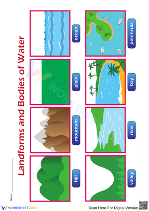
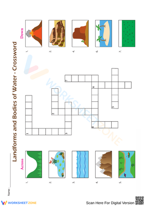
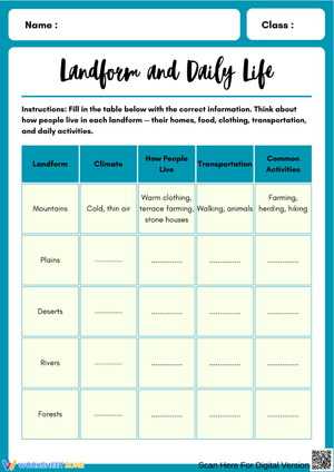
At Grade 5, students need to move beyond basic picture recognition into genuine comparison and explanation. The set covers the six landforms most commonly assessed at this level: mountains, hills, plateaus, plains, valleys, and canyons. But identification is only the entry point. Students also annotate elevation changes on profile diagrams, sort features by likely formation process, and write one-sentence justifications for their answers.
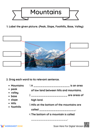
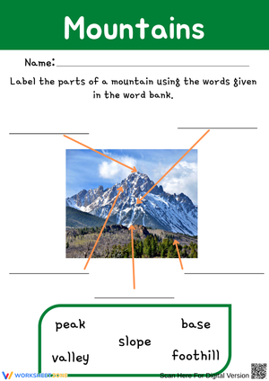
- Mountains and hills: Students compare elevation, steepness, and typical scale rather than simply naming each from a photograph.
- Plateaus and plains: Both are relatively flat, which creates persistent confusion. Each worksheet covering this pair asks students to distinguish the two by elevation, not by surface shape alone.
- Valleys and canyons: Students identify the water-related process most likely responsible and use evidence visible in the diagram to support that identification.
One worksheet introduces short physical map tasks where students match labeled map sections to landform descriptions. That task type appears on many Grade 5 assessments and gives students practice reading topographic clues in context rather than recognizing isolated images.
Landforms as Evidence of Earth System Interactions
The deeper goal at Grade 5 is not vocabulary — it is systems thinking. A canyon records what moving water does to rock over time. A plateau's flat top reflects differential erosion. A valley carved by a glacier looks different from one shaped by a river, and students who notice that distinction are doing the cause-and-effect reasoning the grade standard actually demands. Several worksheets pair a landform image with a short process description and ask students to connect them: This feature formed because... The evidence for that includes...
That frame aligns directly with NGSS 5-ESS2-1, which asks students to use examples to describe interactions among the geosphere, hydrosphere, atmosphere, and biosphere. Worksheets that only ask students to point and label stop short of that standard. These worksheets push into the explanation zone 5-ESS2-1 actually requires, and they work best alongside a brief class discussion before or after the printed task.
Where Student Thinking Gets Tangled — and What to Look For
The plateau-versus-plain confusion is the most persistent error at this grade. Students see "flat" and reach for "plain," even when elevation context sits right there in the image. A specific version: a student will correctly identify the Rocky Mountains from a photograph but then label the Colorado Plateau as a plain on a profile diagram because the top surface is flat. The worksheets address this by including both a visual and an elevation description for every feature-comparison task, requiring students to use both pieces of information before they answer.
The valley-canyon distinction is the second common sticking point. Students often write that canyons are just "big valleys," which misses the process dimension entirely. Prompts that ask students to name the likely shaping agent and then point to evidence in the image expose that gap quickly. If a student writes "water" for both canyon and valley without distinguishing depth, rate, or timeframe, the worksheet gives the teacher a clear record of what still needs reinforcement before the unit assessment.
Fitting These Worksheets Into Your Science Block Without Losing Instructional Time
For unit openers, the labeling worksheet works as a pre-assessment. Students show quickly whether the vocabulary is genuinely new or whether they carry partial knowledge from earlier grades — and that information shapes how much direct instruction the next day actually needs. For centers, pair the sorting and matching worksheets with a map or image card set so students move between the printed task and a physical reference. That back-and-forth reinforces vocabulary without turning center time into silent individual work.
- Bell ringer: project one diagram, ask students to name the landform and write one supporting detail before instruction begins.
- Center rotation: run the sorting worksheet as a paired task — one student defends the sort, the other challenges it.
- Exit ticket: use the constructed-response prompt from the final worksheet in the set and sort students by response quality before the next lesson.
- Reteach block: narrow to three landforms at a time rather than all six. Students who are lost across six features often stabilize quickly when the task is narrowed.
The 5th grade landforms worksheets printable in this set are built so each worksheet stands alone. A teacher running a focused two-day reteach can use just two worksheets without losing the thread of the sequence.
Making These Worksheets Work for the Full Range of Your Class
For students who identify landforms correctly in images but freeze when asked to write an explanation, add sentence frames before they begin: This landform is different from a plain because... or Water may have shaped this feature because the evidence shows... That structure is especially useful for multilingual learners who have the content knowledge but need the academic language made explicit before writing independently. Remove the frames once students use the language reliably on their own — the goal is transfer, not permanent reliance on the frame.
For students who move quickly through the labeling and matching tasks, the map-reading and constructed-response worksheets offer a substantively harder challenge. Asking a student to examine a physical map section, identify two landforms, name a likely shaping process for each, and then compare the two in a single sentence demands far more than labeling six pictures from a diagram. Using the 5th grade landforms worksheets printable this way — with different entry points across the same set — means a mixed-readiness class works from shared materials without requiring the teacher to manage three completely separate assignments.
Standard Alignment
The primary connection is NGSS 5-ESS2-1: Earth's Systems — students develop a model using an example to describe ways the geosphere, biosphere, hydrosphere, and atmosphere interact. Landforms are concrete evidence for that work because they show the visible results of those interactions accumulated over time. A student who can explain how a canyon records the interaction between flowing water and exposed rock is doing exactly what 5-ESS2-1 asks, not just completing a vocabulary exercise.
The worksheets also support the science and engineering practice of constructing explanations from evidence, which runs through Grade 5 Earth science in most state frameworks. Even the shorter identification tasks can be extended by asking students to support their answer with one piece of physical evidence from the diagram — a habit that carries directly into lab reports and science notebook entries.
Frequently Asked Questions
Which landforms are covered in this set?
The set covers the six most commonly assessed landforms at Grade 5: mountains, hills, plateaus, plains, valleys, and canyons. Several worksheets also connect those features to the shaping processes — erosion, deposition, uplift, and weathering — that students study in the same unit.
How are these worksheets different from fill-in-the-blank vocabulary pages?
Most worksheets in this set include at least one task that requires explanation rather than identification alone. Students annotate diagrams, compare feature pairs, read physical map clues, and write short cause-and-effect responses. That task variety gives teachers usable evidence about what students actually understand, not just what they can match from memory.
How do these work for students who are behind on Earth science vocabulary?
The labeling and matching worksheets build the vocabulary base first. Teachers can use those with students who need more exposure before moving into comparison and explanation tasks. Using 5th grade landforms worksheets printable this way — stepping from identification into process-based explanation over several sessions — lets teachers track when vocabulary becomes working knowledge rather than stored definitions.
Do these work alongside a textbook or published science kit?
Each worksheet functions independently as a pre-instruction check, mid-unit practice task, center activity, or post-lesson review. They fit within a unit that already has an anchor text or investigation sequence rather than replacing it.