


















Views
Downloads


Ready Africa Lat/Long Worksheet | Grades 5-7 Social Studies
Paste this activity's link or code into your existing LMS (Google Classroom, Canvas, Teams, Schoology, Moodle, etc.).
Students can open and work on the activity right away, with no student login required.
You'll still be able to track student progress and results from your teacher account.
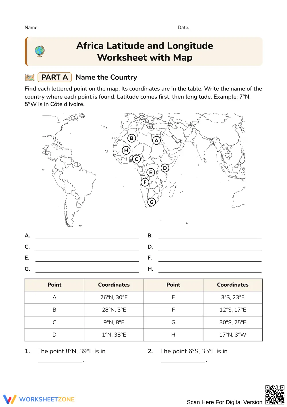
This worksheet teaches students to read and write latitude and longitude on a map of Africa. Students name countries from coordinates, write coordinates for capital cities, and identify which major lines of latitude and longitude cross the continent.
At a Glance
- Grade: 5–7 · Subject: Social Studies
- Standard: Not specified — students use coordinates to locate places in Africa
- Skill Focus: Reading and writing coordinates on an Africa map
- Format: 2 pages · 27 problems · Answer key included · PDF
- Best For: Geography skills practice and review
- Time: 25–35 minutes
What's Inside
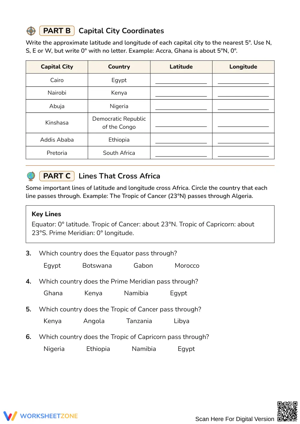
The worksheet has three parts across 2 printable pages. Part A shows an Africa map with lettered points and a coordinate table, and students write the country at each point. A word bank lists the country names. Part B asks students to write the approximate latitude and longitude of six capital cities to the nearest 5 degrees. Part C is a multiple-choice set on the Equator, Prime Meridian, Tropic of Cancer, and Tropic of Capricorn, with a key-lines reference box. Each part has a worked example, and the 2-page answer key shows every response.
Skill Progression
- Guided practice: Part A gives a worked example and a word bank. Students match eight lettered points to countries, with latitude always listed first.
- Supported practice: Part C gives a key-lines reference box and four multiple-choice questions on the lines that cross Africa.
- Independent practice: Part B asks students to write coordinates for six capitals, using N, S, E, or W and writing 0° with no letter.
The parts follow a gradual-release model (I Do, We Do, You Do): model the example, practice together, then release students to work alone.
Standards Alignment
No standard code was supplied for this worksheet, so none is listed. The tasks address a common geography skill: using a coordinate grid of latitude and longitude to describe the absolute location of places. Add your state or district geography standard code when you record this resource in lesson plans, IEP goals, or curriculum mapping tools.
How to Use It
- After direct instruction: Assign the worksheet once you have taught how to read latitude and longitude. Students work alone or in pairs.
- As a review station: Use Part C as a short warm-up before a map quiz or unit test.
While students work, watch whether they put latitude before longitude and whether they use the correct N, S, E, or W letters. These are the most common errors.
Who It's For
The worksheet suits students in Grades 5–7 who are learning to use map coordinates. The word bank, worked examples, and key-lines box support students who need more structure. Students who finish early can find extra capitals in an atlas and write their coordinates. Pair it with a classroom world map or a short lesson on the Equator and Prime Meridian.
This Grades 5–7 Social Studies worksheet builds the skill of locating places in Africa with latitude and longitude. Students name countries from coordinate pairs, write approximate coordinates for six capital cities, and identify which country each major line of latitude or longitude crosses. The 27 tasks move from guided examples with a word bank to independent coordinate writing, which follows the gradual-release model described by Fisher & Frey (2014). Geography instruction often treats coordinate reading as foundational, because students must connect numbers to places on a map. This resource has no standard code attached, so teachers can align it to the geography standards they use. The 2-page answer key shows every response, so teachers can check work quickly and see which skills need reteaching.


