


















Views
Downloads


Free Lat & Long Lines Worksheet | Grades 4–7 Social Studies

Paste this activity's link or code into your existing LMS (Google Classroom, Canvas, Teams, Schoology, Moodle, etc.).
Students can open and work on the activity right away, with no student login required.
You'll still be able to track student progress and results from your teacher account.
This worksheet helps students in Grades 4–7 identify and label the named lines of latitude and longitude on a globe and a world map. Students also learn each line's degree and meaning, building the geography vocabulary needed to read maps and locate places with confidence.
At a Glance
- Grade: 4–7 · Subject: Social Studies
- Standard: Map-skills geography (add your state code) — label grid lines and state their degrees.
- Skill Focus: Naming parallels, meridians, and key reference lines
- Format: 2 pages · 19 problems · Answer key included · PDF
- Best For: Introducing globe and map grid lines
- Time: 20–30 minutes
What's Inside
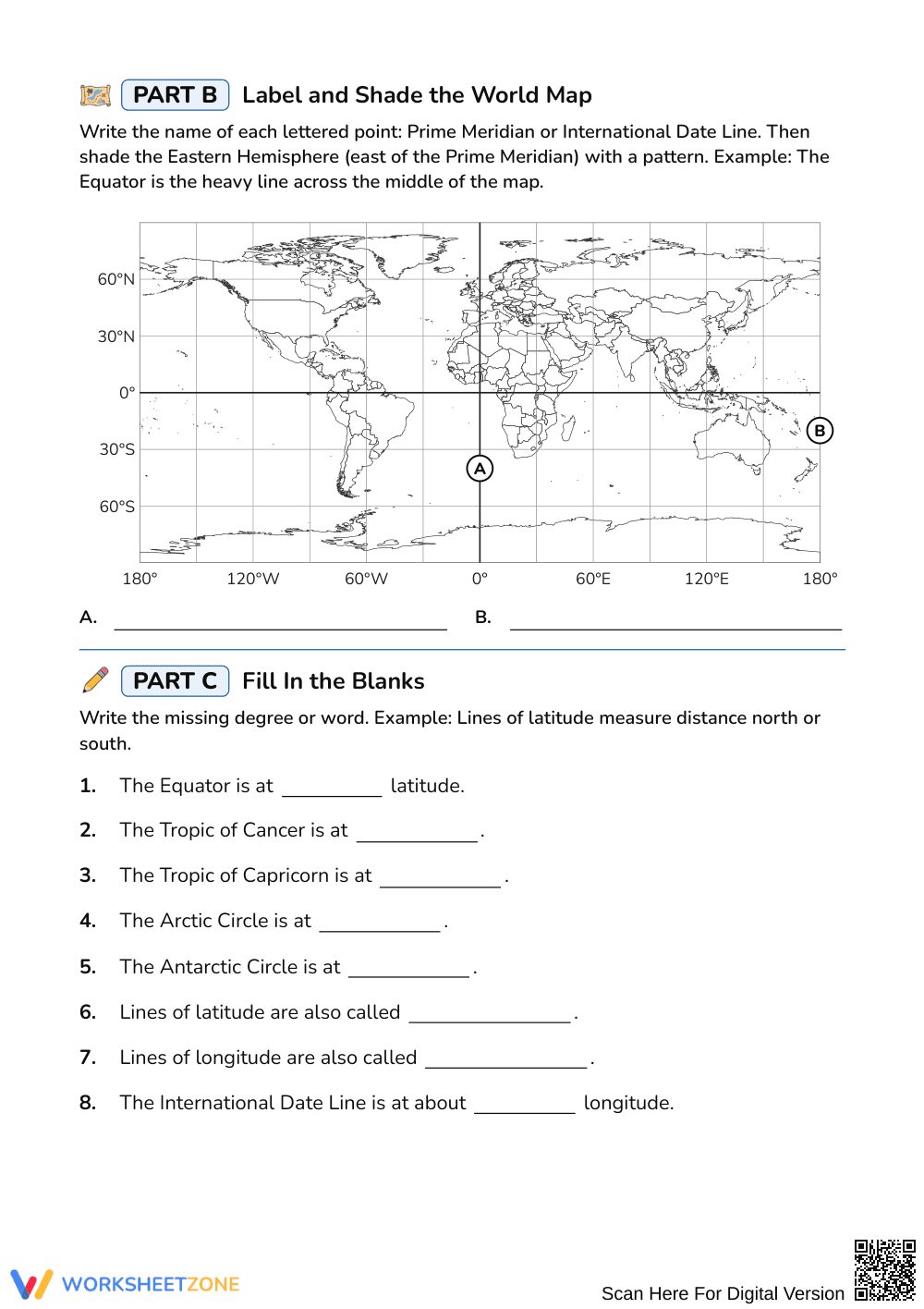
The 2-page worksheet has three parts. Part A asks students to label a globe using a word bank of eight terms: the North Pole, South Pole, Equator, Tropic of Cancer, Tropic of Capricorn, Arctic Circle, Antarctic Circle, and Prime Meridian. Part B uses a world map with grid lines every 30 degrees; students label the Prime Meridian and International Date Line, then shade the Eastern Hemisphere with a pattern. Part C has eight fill-in-the-blank statements on degrees and vocabulary. Each part opens with a short example. A 2-page answer key is included.
Skill Progression
- Guided practice: Part A, 8 labels from a word bank on a globe, with a worked example at the top.
- Supported practice: Part B, 3 tasks on a gridded world map: two labels and one shading task, with an example line.
- Independent practice: Part C, 8 fill-in-the-blank statements recalling degrees such as 23.5°N and 66.5°S, plus the terms parallels and meridians.
Standards Alignment
This worksheet supports state and district social studies geography standards on using maps and globes, including the global grid of latitude and longitude. No single standard code is attached to it, so add your own state code when you file it.
How to Use It
- During direct instruction: Project a globe, model the first label, and let students finish Part A with partners. Walk the room and listen for students confusing the Tropics with the polar circles.
- After instruction: Assign Parts B and C as independent practice or a quick check, then review with the answer key.
Expect 20 to 30 minutes. Students who shade the wrong side of the Prime Meridian in Part B usually need a quick review of east versus west.
Who It's For
This resource suits students in Grades 4–7 meeting latitude and longitude for the first time, and older students reviewing map skills. The word bank, examples, and gridded map support emerging readers and English learners. Fast finishers can add the lines to a blank map from memory.
Label Lines of Latitude and Longitude is a 2-page Grades 4–7 social studies worksheet with 19 tasks in which students name the Equator, Tropic of Cancer, Tropic of Capricorn, Arctic Circle, Antarctic Circle, Prime Meridian, and International Date Line on a globe and world map, and state their degrees. It does not carry a specific standard code, so it works with any state geography map-skills standard. Its design follows the gradual release model described by Fisher & Frey (2014), which moves learners from teacher modeling to guided practice and then independent work. Students label with a word bank first, then work on a gridded map, then recall degree values and the terms parallels and meridians without support. A 2-page answer key makes checking quick for teachers.


